Querfurt geodata
Querfurt (Saxony-Anhalt) is a populated place; located in Germany in Europe/Berlin (GMT+2) time zone. With population of 9,019 people, there are 1784 cities with bigger population in this country. Compared to other cities in Germany, 64.4% of cities are located further ↓South; 75.8% of cities are located further ←West and 58.1% of cities have higher elevation than Querfurt. Note1


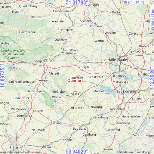
Querfurt GPS coordinates[2]
51° 22' 52.464" North, 11° 36' 1.692" East
| Map corner | latitude | longitude |
|---|---|---|
| Upper-left | 51.81798°, | 10.89735° |
| Center: | 51.38124°, | 11.60047° |
| Lower-right: | 50.94029°, | 12.3036° |
| Map W x H: | 97.6×97.6 km | = 60.6×60.6mi |
| max Lat: | 55.01917° ⇑35.6% North |
| Querfurt: | 51.38124° |
| min Lat: | ⇓64.4% South 47.40724° |
| min Long | Querfurt | max Long |
| 5.92978° | 11.60047° | 14.98853° |
| W 75.8%⇐ | ⇒24.2% E |
Elevation
Elevation of Querfurt is 167 m = 548 ft, and this is 82.1 m = 269 ft below average elevation for this country.
| Max E: |
1256 m = 4121 ft | 58.1% |
| Avg. | 249.1 m = 817 ft | |
| Querfurt | 167 m = 548 ft | |
Min E: |
-5 m = -16 ft | 41.9% |
See also: Germany elevation on elevation.city.
Geographical zone
Querfurt is located in North temperate zone (between Tropic of Cancer and the Arctic Circle). Distance of this North polar circle is 1688.1 km =1048.9 mi to North.| Distance of | km | miles | from Querfurt |
|---|---|---|---|
| North Pole | 4294 | 2668.2 | to North |
| Arctic Circle | 1688.1 | 1048.9 | to North |
| Tropic Cancer | 3107.1 | 1930.7 | to South |
| Equator | 5713.1 | 3550 | to South |


Nearby cities:
15 places around Querfurt: (largest is in red/bold)
• Alberstedt
7.6 km =4.7 mi,  13°
13°
• Barnstädt
4.9 km =3 mi,  148°
148°
• Esperstedt
7.2 km =4.5 mi,  48°
48°
• Farnstädt
6.2 km =3.9 mi,  337°
337°
• Nebra
10.5 km =6.5 mi,  188°
188°
• Nemsdorf-Göhrendorf
4.9 km =3 mi,  135°
135°
• Obhausen
3.8 km =2.4 mi,  72°
72°
• Rothenschirmbach
9.1 km =5.7 mi, 335°
• Röblingen am See
10.4 km =6.5 mi,  33°
33°
• Schmon
5.6 km =3.5 mi,  224°
224°
• Schraplau
7.8 km =4.8 mi,  36°
36°
• Stedten
9.4 km =5.8 mi, 42°
• Steigra
10.1 km =6.3 mi, 153°
• Vitzenburg
9.1 km =5.7 mi, 194°
• Weißenschirmbach
8.2 km =5.1 mi,  204°
204°
Sources, notices
• [Note1] Compared only with cities in Germany existing in our database
• [Src1] Map data: © OpenStreetMap contributors (CC-BY-SA)
• [Src2] Other city data from geonames.org with taken over terms of usage.
• [Src3] Geographical zone / Annual Mean Temperature by Robert A. Rohde @ Wikipedia
