Schaafheim geodata
Schaafheim (Hesse) is a seat of a fourth-order administrative division; located in Germany in Europe/Berlin (GMT+2) time zone. With population of 8,784 people, there are 1826 cities with bigger population in this country. Compared to other cities in Germany, 65.7% of cities are located further ↑North; 65.3% of cities are located further →East and 60.1% of cities have higher elevation than Schaafheim. Note1
Administrative division(s):
- Level 1: Hesse
- Level 2: Regierungsbezirk Darmstadt
- Level 3: Landkreis Darmstadt-Dieburg
- Level 4: Schaafheim


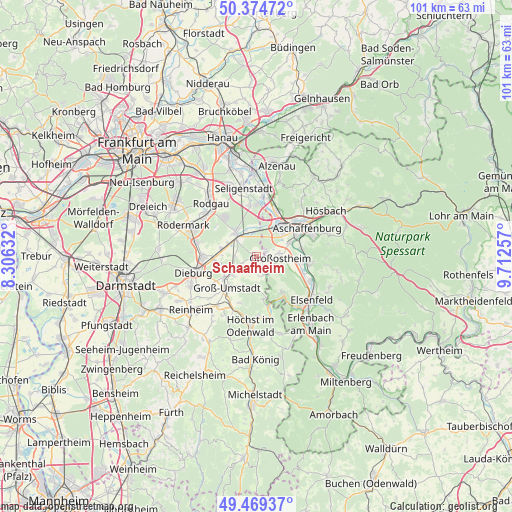
Schaafheim GPS coordinates[2]
49° 55' 27.012" North, 9° 0' 33.984" East
| Map corner | latitude | longitude |
|---|---|---|
| Upper-left | 50.37472°, | 8.30632° |
| Center: | 49.92417°, | 9.00944° |
| Lower-right: | 49.46937°, | 9.71257° |
| Map W x H: | 100.7×100.7 km | = 62.6×62.6mi |
| max Lat: | 55.01917° ⇑65.7% North |
| Schaafheim: | 49.92417° |
| min Lat: | ⇓34.3% South 47.40724° |
| min Long | Schaafheim | max Long |
| 5.92978° | 9.00944° | 14.98853° |
| W 34.7%⇐ | ⇒65.3% E |
Elevation
Elevation of Schaafheim is 151 m = 495 ft, and this is 98.1 m = 322 ft below average elevation for this country.
| Max E: |
1256 m = 4121 ft | 60.1% |
| Avg. | 249.1 m = 817 ft | |
| Schaafheim | 151 m = 495 ft | |
Min E: |
-5 m = -16 ft | 39.9% |
See also: Germany elevation on elevation.city.
Geographical zone
Schaafheim is located in North temperate zone (between Tropic of Cancer and the Arctic Circle). Distance of this North polar circle is 1850.1 km =1149.6 mi to North.| Distance of | km | miles | from Schaafheim |
|---|---|---|---|
| North Pole | 4456 | 2768.8 | to North |
| Arctic Circle | 1850.1 | 1149.6 | to North |
| Tropic Cancer | 2945.1 | 1830 | to South |
| Equator | 5551 | 3449.2 | to South |


Nearby cities:
15 places around Schaafheim: (largest is in red/bold)
• Aschaffenburg
11.8 km =7.3 mi,  60°
60°
• Babenhausen
6.2 km =3.9 mi,  317°
317°
• Dieburg
12.1 km =7.5 mi,  255°
255°
• Eppertshausen
11.5 km =7.1 mi,  284°
284°
• Groß-Umstadt
8.3 km =5.2 mi,  222°
222°
• Großostheim
4.8 km =3 mi,  95°
95°
• Großwallstadt
11.4 km =7.1 mi,  115°
115°
• Kleinostheim
9.4 km =5.8 mi,  25°
25°
• Kleinwallstadt
12.7 km =7.9 mi, 115°
• Mainaschaff
8.6 km =5.3 mi,  42°
42°
• Mömlingen
8.9 km =5.5 mi,  143°
143°
• Münster
10.1 km =6.3 mi,  269°
269°
• Niedernberg
9.2 km =5.7 mi, 98°
• Stockstadt am Main
6.8 km =4.2 mi, 41°
• Sulzbach am Main
10.4 km =6.5 mi, 97°
Sources, notices
• [Note1] Compared only with cities in Germany existing in our database
• [Src1] Map data: © OpenStreetMap contributors (CC-BY-SA)
• [Src2] Other city data from geonames.org with taken over terms of usage.
• [Src3] Geographical zone / Annual Mean Temperature by Robert A. Rohde @ Wikipedia
