Babenhausen geodata
Babenhausen (Hesse) is a populated place; located in Germany in Europe/Berlin (GMT+2) time zone. With population of 16,575 people, there are 953 cities with bigger population in this country. Compared to other cities in Germany, 64.8% of cities are located further ↑North; 66% of cities are located further →East and 63.9% of cities have higher elevation than Babenhausen. Note1
Administrative division(s):
- Level 1: Hesse
- Level 2: Regierungsbezirk Darmstadt
- Level 3: Landkreis Darmstadt-Dieburg
- Level 4: Babenhausen


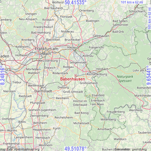
Babenhausen GPS coordinates[2]
49° 57' 54.684" North, 8° 57' 4.644" East
| Map corner | latitude | longitude |
|---|---|---|
| Upper-left | 50.41535°, | 8.24816° |
| Center: | 49.96519°, | 8.95129° |
| Lower-right: | 49.51078°, | 9.65441° |
| Map W x H: | 100.6×100.6 km | = 62.5×62.5mi |
| max Lat: | 55.01917° ⇑64.8% North |
| Babenhausen: | 49.96519° |
| min Lat: | ⇓35.2% South 47.40724° |
| min Long | Babenhausen | max Long |
| 5.92978° | 8.95129° | 14.98853° |
| W 34%⇐ | ⇒66% E |
Elevation
Elevation of Babenhausen is 127 m = 417 ft, and this is 122.1 m = 401 ft below average elevation for this country.
| Max E: |
1256 m = 4121 ft | 63.9% |
| Avg. | 249.1 m = 817 ft | |
| Babenhausen | 127 m = 417 ft | |
Min E: |
-5 m = -16 ft | 36.1% |
See also: Germany elevation on elevation.city.
Geographical zone
Babenhausen is located in North temperate zone (between Tropic of Cancer and the Arctic Circle). Distance of this North polar circle is 1845.6 km =1146.8 mi to North.| Distance of | km | miles | from Babenhausen |
|---|---|---|---|
| North Pole | 4451.5 | 2766 | to North |
| Arctic Circle | 1845.6 | 1146.8 | to North |
| Tropic Cancer | 2949.7 | 1832.9 | to South |
| Equator | 5555.6 | 3452.1 | to South |


Nearby cities:
15 places around Babenhausen: (largest is in red/bold)
• Dieburg
10.7 km =6.6 mi,  224°
224°
• Dietzenbach
13.4 km =8.3 mi,  291°
291°
• Eppertshausen
7.2 km =4.5 mi,  256°
256°
• Groß-Umstadt
10.8 km =6.7 mi,  187°
187°
• Groß-Zimmern
13.4 km =8.3 mi, 220°
• Großkrotzenburg
13.3 km =8.3 mi,  9°
9°
• Großostheim
10.2 km =6.3 mi,  119°
119°
• Kahl am Main
12.3 km =7.6 mi,  18°
18°
• Kleinostheim
9.1 km =5.7 mi,  64°
64°
• Mainaschaff
10.1 km =6.3 mi,  79°
79°
• Münster
7.6 km =4.7 mi,  231°
231°
• Rodgau
8.2 km =5.1 mi,  325°
325°
• Schaafheim
6.2 km =3.9 mi,  137°
137°
• Seligenstadt
8.8 km =5.5 mi, 10°
• Stockstadt am Main
8.6 km =5.3 mi,  86°
86°
Sources, notices
• [Note1] Compared only with cities in Germany existing in our database
• [Src1] Map data: © OpenStreetMap contributors (CC-BY-SA)
• [Src2] Other city data from geonames.org with taken over terms of usage.
• [Src3] Geographical zone / Annual Mean Temperature by Robert A. Rohde @ Wikipedia
