Sasbach geodata
Sasbach (Baden-Württemberg) is a populated place; located in Germany in Europe/Berlin (GMT+2) time zone. With population of 3,369 people, there are 3705 cities with bigger population in this country. Compared to other cities in Germany, 93.5% of cities are located further ↑North; 84.8% of cities are located further →East and 56.5% of cities have higher elevation than Sasbach. Note1
Administrative division(s):
- Level 1: Baden-Württemberg
- Level 2: Freiburg Region
- Level 3: Landkreis Emmendingen
- Level 4: Sasbach am Kaiserstuhl


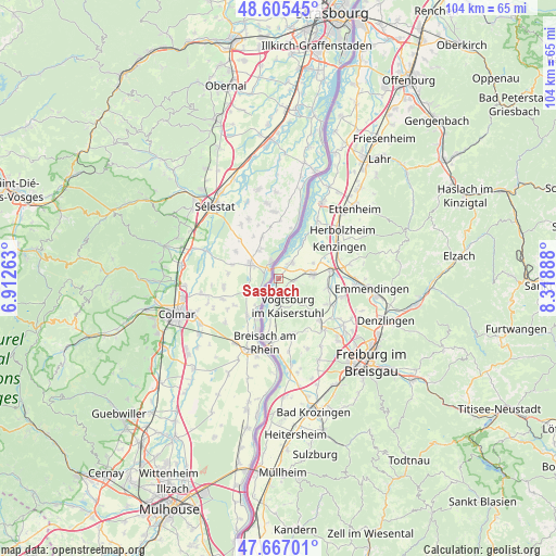
Sasbach GPS coordinates[2]
48° 8' 18.132" North, 7° 36' 56.736" East
| Map corner | latitude | longitude |
|---|---|---|
| Upper-left | 48.60545°, | 6.91263° |
| Center: | 48.13837°, | 7.61576° |
| Lower-right: | 47.66701°, | 8.31888° |
| Map W x H: | 104.3×104.3 km | = 64.8×64.8mi |
| max Lat: | 55.01917° ⇑93.5% North |
| Sasbach: | 48.13837° |
| min Lat: | ⇓6.5% South 47.40724° |
| min Long | Sasbach | max Long |
| 5.92978° | 7.61576° | 14.98853° |
| W 15.2%⇐ | ⇒84.8% E |
Elevation
Elevation of Sasbach is 178 m = 584 ft, and this is 71.1 m = 233 ft below average elevation for this country.
| Max E: |
1256 m = 4121 ft | 56.5% |
| Avg. | 249.1 m = 817 ft | |
| Sasbach | 178 m = 584 ft | |
Min E: |
-5 m = -16 ft | 43.5% |
See also: Germany elevation on elevation.city.
Geographical zone
Sasbach is located in North temperate zone (between Tropic of Cancer and the Arctic Circle). Distance of this North polar circle is 2048.7 km =1273 mi to North.| Distance of | km | miles | from Sasbach |
|---|---|---|---|
| North Pole | 4654.6 | 2892.2 | to North |
| Arctic Circle | 2048.7 | 1273 | to North |
| Tropic Cancer | 2746.6 | 1706.7 | to South |
| Equator | 5352.5 | 3325.9 | to South |


Nearby cities:
15 places around Sasbach: (largest is in red/bold)
• Bahlingen
9.4 km =5.8 mi,  102°
102°
• Bischoffingen
3.9 km =2.4 mi,  167°
167°
• Breisach am Rhein
12 km =7.5 mi,  191°
191°
• Bötzingen
10.6 km =6.6 mi,  130°
130°
• Eichstetten
10.6 km =6.6 mi,  117°
117°
• Endingen
6.3 km =3.9 mi,  86°
86°
• Forchheim
7 km =4.3 mi,  63°
63°
• Ihringen
10.9 km =6.8 mi, 167°
• Kenzingen
13.1 km =8.1 mi, 60°
• Malterdingen
12.8 km =8 mi,  80°
80°
• Oberrotweil
5.6 km =3.5 mi,  164°
164°
• Riegel
10 km =6.2 mi, 81°
• Vogtsburg
5 km =3.1 mi, 157°
• Weisweil
8.2 km =5.1 mi,  33°
33°
• Wyhl
4 km =2.5 mi,  38°
38°
Sources, notices
• [Note1] Compared only with cities in Germany existing in our database
• [Src1] Map data: © OpenStreetMap contributors (CC-BY-SA)
• [Src2] Other city data from geonames.org with taken over terms of usage.
• [Src3] Geographical zone / Annual Mean Temperature by Robert A. Rohde @ Wikipedia
