Riegel geodata
Riegel (Baden-Württemberg) is a populated place; located in Germany in Europe/Berlin (GMT+2) time zone. With population of 3,544 people, there are 3580 cities with bigger population in this country. Compared to other cities in Germany, 93.3% of cities are located further ↑North; 82.2% of cities are located further →East and 55.8% of cities have higher elevation than Riegel. Note1
Administrative division(s):
- Level 1: Baden-Württemberg
- Level 2: Freiburg Region
- Level 3: Landkreis Emmendingen
- Level 4: Riegel am Kaiserstuhl


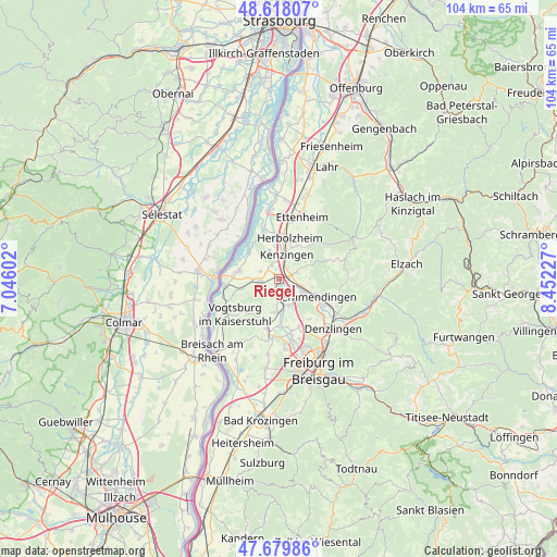
Riegel GPS coordinates[2]
48° 9' 3.996" North, 7° 44' 56.94" East
| Map corner | latitude | longitude |
|---|---|---|
| Upper-left | 48.61807°, | 7.04602° |
| Center: | 48.15111°, | 7.74915° |
| Lower-right: | 47.67986°, | 8.45227° |
| Map W x H: | 104.3×104.3 km | = 64.8×64.8mi |
| max Lat: | 55.01917° ⇑93.3% North |
| Riegel: | 48.15111° |
| min Lat: | ⇓6.7% South 47.40724° |
| min Long | Riegel | max Long |
| 5.92978° | 7.74915° | 14.98853° |
| W 17.8%⇐ | ⇒82.2% E |
Elevation
Elevation of Riegel is 183 m = 600 ft, and this is 66.1 m = 217 ft below average elevation for this country.
| Max E: |
1256 m = 4121 ft | 55.8% |
| Avg. | 249.1 m = 817 ft | |
| Riegel | 183 m = 600 ft | |
Min E: |
-5 m = -16 ft | 44.2% |
See also: Germany elevation on elevation.city.
Geographical zone
Riegel is located in North temperate zone (between Tropic of Cancer and the Arctic Circle). Distance of this North polar circle is 2047.3 km =1272.1 mi to North.| Distance of | km | miles | from Riegel |
|---|---|---|---|
| North Pole | 4653.2 | 2891.4 | to North |
| Arctic Circle | 2047.3 | 1272.1 | to North |
| Tropic Cancer | 2748 | 1707.5 | to South |
| Equator | 5353.9 | 3326.8 | to South |


Nearby cities:
15 places around Riegel: (largest is in red/bold)
• Bahlingen
3.5 km =2.2 mi,  191°
191°
• Buchheim
10.3 km =6.4 mi,  170°
170°
• Bötzingen
8.5 km =5.3 mi, 192°
• Eichstetten
6.3 km =3.9 mi,  184°
184°
• Emmendingen
8.4 km =5.2 mi,  113°
113°
• Endingen
3.7 km =2.3 mi,  254°
254°
• Forchheim
4 km =2.5 mi,  295°
295°
• Herbolzheim
7.8 km =4.8 mi,  15°
15°
• Kenzingen
5.3 km =3.3 mi, 16°
• Malterdingen
2.8 km =1.7 mi,  76°
76°
• Sasbach
10 km =6.2 mi,  261°
261°
• Teningen
5.2 km =3.2 mi,  117°
117°
• Vogtsburg
10 km =6.2 mi,  232°
232°
• Weisweil
7.6 km =4.7 mi,  315°
315°
• Wyhl
7.6 km =4.7 mi,  282°
282°
Sources, notices
• [Note1] Compared only with cities in Germany existing in our database
• [Src1] Map data: © OpenStreetMap contributors (CC-BY-SA)
• [Src2] Other city data from geonames.org with taken over terms of usage.
• [Src3] Geographical zone / Annual Mean Temperature by Robert A. Rohde @ Wikipedia
