Wyhl geodata
Wyhl (Baden-Württemberg) is a populated place; located in Germany in Europe/Berlin (GMT+2) time zone. With population of 3,645 people, there are 3510 cities with bigger population in this country. Compared to other cities in Germany, 93.2% of cities are located further ↑North; 84% of cities are located further →East and 57% of cities have higher elevation than Wyhl. Note1
Administrative division(s):
- Level 1: Baden-Württemberg
- Level 2: Freiburg Region
- Level 3: Landkreis Emmendingen
- Level 4: Wyhl am Kaiserstuhl


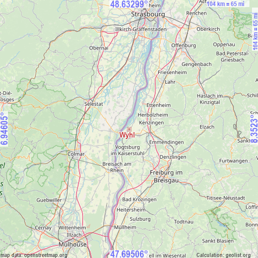
Wyhl GPS coordinates[2]
48° 9' 58.212" North, 7° 38' 57.012" East
| Map corner | latitude | longitude |
|---|---|---|
| Upper-left | 48.63299°, | 6.94605° |
| Center: | 48.16617°, | 7.64917° |
| Lower-right: | 47.69506°, | 8.3523° |
| Map W x H: | 104.3×104.3 km | = 64.8×64.8mi |
| max Lat: | 55.01917° ⇑93.2% North |
| Wyhl: | 48.16617° |
| min Lat: | ⇓6.8% South 47.40724° |
| min Long | Wyhl | max Long |
| 5.92978° | 7.64917° | 14.98853° |
| W 16%⇐ | ⇒84% E |
Elevation
Elevation of Wyhl is 175 m = 574 ft, and this is 74.1 m = 243 ft below average elevation for this country.
| Max E: |
1256 m = 4121 ft | 57% |
| Avg. | 249.1 m = 817 ft | |
| Wyhl | 175 m = 574 ft | |
Min E: |
-5 m = -16 ft | 43% |
See also: Germany elevation on elevation.city.
Geographical zone
Wyhl is located in North temperate zone (between Tropic of Cancer and the Arctic Circle). Distance of this North polar circle is 2045.6 km =1271.1 mi to North.| Distance of | km | miles | from Wyhl |
|---|---|---|---|
| North Pole | 4651.5 | 2890.3 | to North |
| Arctic Circle | 2045.6 | 1271.1 | to North |
| Tropic Cancer | 2749.7 | 1708.6 | to South |
| Equator | 5355.6 | 3327.8 | to South |


Nearby cities:
15 places around Wyhl: (largest is in red/bold)
• Bahlingen
8.4 km =5.2 mi,  126°
126°
• Bischoffingen
7.1 km =4.4 mi,  193°
193°
• Bötzingen
11.5 km =7.1 mi,  150°
150°
• Eichstetten
10.6 km =6.6 mi,  139°
139°
• Endingen
4.6 km =2.9 mi,  124°
124°
• Forchheim
3.8 km =2.4 mi,  89°
89°
• Herbolzheim
11.2 km =7 mi,  58°
58°
• Kenzingen
9.5 km =5.9 mi,  69°
69°
• Malterdingen
10.2 km =6.3 mi,  95°
95°
• Oberrotweil
8.5 km =5.3 mi, 186°
• Riegel
7.6 km =4.7 mi, 102°
• Rust
12.8 km =8 mi,  29°
29°
• Sasbach
4 km =2.5 mi,  218°
218°
• Vogtsburg
7.7 km =4.8 mi,  184°
184°
• Weisweil
4.2 km =2.6 mi, 29°
Sources, notices
• [Note1] Compared only with cities in Germany existing in our database
• [Src1] Map data: © OpenStreetMap contributors (CC-BY-SA)
• [Src2] Other city data from geonames.org with taken over terms of usage.
• [Src3] Geographical zone / Annual Mean Temperature by Robert A. Rohde @ Wikipedia
