Sankt Wolfgang geodata
Sankt Wolfgang (Bavaria) is a seat of a fourth-order administrative division; located in Germany in Europe/Berlin (GMT+2) time zone. With population of 4,102 people, there are 3230 cities with bigger population in this country. Compared to other cities in Germany, 92.5% of cities are located further ↑North; 83.6% of cities are located further ←West and 90.8% of cities have lower elevation than Sankt Wolfgang. Note1
Administrative division(s):
- Level 1: Bavaria
- Level 2: Upper Bavaria
- Level 3: Landkreis Erding
- Level 4: Sankt Wolfgang


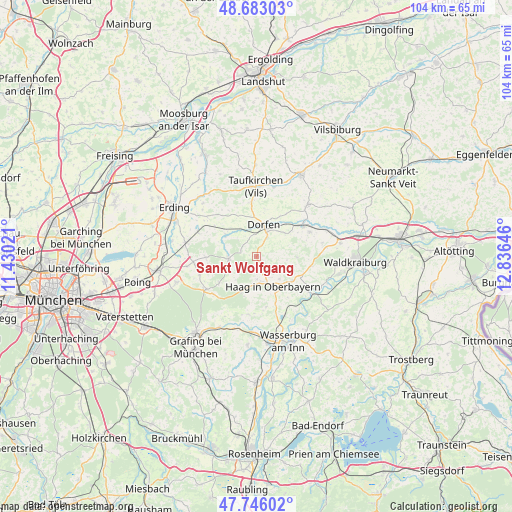
Sankt Wolfgang GPS coordinates[2]
48° 13' 0.012" North, 12° 7' 59.988" East
| Map corner | latitude | longitude |
|---|---|---|
| Upper-left | 48.68303°, | 11.43021° |
| Center: | 48.21667°, | 12.13333° |
| Lower-right: | 47.74602°, | 12.83646° |
| Map W x H: | 104.2×104.2 km | = 64.7×64.7mi |
| max Lat: | 55.01917° ⇑92.5% North |
| Sankt Wolfgang: | 48.21667° |
| min Lat: | ⇓7.5% South 47.40724° |
| min Long | Sankt Wolfgang | max Long |
| 5.92978° | 12.13333° | 14.98853° |
| W 83.6%⇐ | ⇒16.4% E |
Elevation
Elevation of Sankt Wolfgang is 525 m = 1722 ft, and this is 275.9 m = 905 ft above average elevation for this country.
| Max E: |
1256 m = 4121 ft | 9.2% |
| Sankt Wolfgang | 525 m 1722 ft | |
| Avg. | 249.1 m = 817 ft | |
Min E: |
-5 m = -16 ft | 90.8% |
See also: Germany elevation on elevation.city.
Geographical zone
Sankt Wolfgang is located in North temperate zone (between Tropic of Cancer and the Arctic Circle). Distance of this North polar circle is 2040 km =1267.6 mi to North.| Distance of | km | miles | from Sankt Wolfgang |
|---|---|---|---|
| North Pole | 4645.9 | 2886.8 | to North |
| Arctic Circle | 2040 | 1267.6 | to North |
| Tropic Cancer | 2755.3 | 1712.1 | to South |
| Equator | 5361.2 | 3331.3 | to South |


Nearby cities:
15 places around Sankt Wolfgang: (largest is in red/bold)
• Albaching
12 km =7.5 mi,  188°
188°
• Altdorf
7.9 km =4.9 mi,  151°
151°
• Buch am Buchrain
10.2 km =6.3 mi,  269°
269°
• Dorfen
6.3 km =3.9 mi,  18°
18°
• Forstern
12.1 km =7.5 mi,  252°
252°
• Haag in Oberbayern
7 km =4.3 mi, 150°
• Isen
5.7 km =3.5 mi,  264°
264°
• Kirchdorf
6.6 km =4.1 mi,  134°
134°
• Lengdorf
7.7 km =4.8 mi,  306°
306°
• Maitenbeth
7.9 km =4.9 mi,  201°
201°
• Obertaufkirchen
11.8 km =7.3 mi,  65°
65°
• Ramsau
8.6 km =5.3 mi,  124°
124°
• Rechtmehring
11.4 km =7.1 mi,  167°
167°
• Reichertsheim
11.3 km =7 mi,  99°
99°
• Schwindegg
11.2 km =7 mi,  56°
56°
Sources, notices
• [Note1] Compared only with cities in Germany existing in our database
• [Src1] Map data: © OpenStreetMap contributors (CC-BY-SA)
• [Src2] Other city data from geonames.org with taken over terms of usage.
• [Src3] Geographical zone / Annual Mean Temperature by Robert A. Rohde @ Wikipedia
