Maitenbeth geodata
Maitenbeth (Bavaria) is a seat of a fourth-order administrative division; located in Germany in Europe/Berlin (GMT+2) time zone. With population of 1,868 people, there are 5250 cities with bigger population in this country. Compared to other cities in Germany, 93.3% of cities are located further ↑North; 83.1% of cities are located further ←West and 95.1% of cities have lower elevation than Maitenbeth. Note1
Administrative division(s):
- Level 1: Bavaria
- Level 2: Upper Bavaria
- Level 3: Landkreis Mühldorf am Inn
- Level 4: Maitenbeth


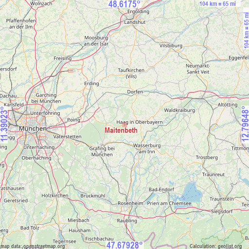
Maitenbeth GPS coordinates[2]
48° 9' 1.908" North, 12° 5' 36.06" East
| Map corner | latitude | longitude |
|---|---|---|
| Upper-left | 48.6175°, | 11.39023° |
| Center: | 48.15053°, | 12.09335° |
| Lower-right: | 47.67928°, | 12.79648° |
| Map W x H: | 104.3×104.3 km | = 64.8×64.8mi |
| max Lat: | 55.01917° ⇑93.3% North |
| Maitenbeth: | 48.15053° |
| min Lat: | ⇓6.7% South 47.40724° |
| min Long | Maitenbeth | max Long |
| 5.92978° | 12.09335° | 14.98853° |
| W 83.1%⇐ | ⇒16.9% E |
Elevation
Elevation of Maitenbeth is 602 m = 1975 ft, and this is 352.9 m = 1158 ft above average elevation for this country.
| Max E: |
1256 m = 4121 ft | 4.9% |
| Maitenbeth | 602 m 1975 ft | |
| Avg. | 249.1 m = 817 ft | |
Min E: |
-5 m = -16 ft | 95.1% |
See also: Germany elevation on elevation.city.
Geographical zone
Maitenbeth is located in North temperate zone (between Tropic of Cancer and the Arctic Circle). Distance of this North polar circle is 2047.3 km =1272.1 mi to North.| Distance of | km | miles | from Maitenbeth |
|---|---|---|---|
| North Pole | 4653.2 | 2891.4 | to North |
| Arctic Circle | 2047.3 | 1272.1 | to North |
| Tropic Cancer | 2747.9 | 1707.5 | to South |
| Equator | 5353.8 | 3326.7 | to South |


Nearby cities:
15 places around Maitenbeth: (largest is in red/bold)
• Albaching
4.7 km =2.9 mi,  163°
163°
• Altdorf
6.7 km =4.2 mi,  86°
86°
• Buch am Buchrain
10.2 km =6.3 mi,  314°
314°
• Edling
11.8 km =7.3 mi,  153°
153°
• Forstern
9.4 km =5.8 mi,  293°
293°
• Haag in Oberbayern
6.5 km =4 mi,  78°
78°
• Hohenlinden
7.4 km =4.6 mi,  274°
274°
• Isen
7.4 km =4.6 mi,  338°
338°
• Kirchdorf
8.1 km =5 mi,  70°
70°
• Pfaffing
10.7 km =6.6 mi,  173°
173°
• Ramsau
10.4 km =6.5 mi, 76°
• Rechtmehring
6.6 km =4.1 mi,  124°
124°
• Sankt Wolfgang
7.9 km =4.9 mi,  21°
21°
• Soyen
9.9 km =6.2 mi, 118°
• Steinhöring
8.4 km =5.2 mi,  212°
212°
Sources, notices
• [Note1] Compared only with cities in Germany existing in our database
• [Src1] Map data: © OpenStreetMap contributors (CC-BY-SA)
• [Src2] Other city data from geonames.org with taken over terms of usage.
• [Src3] Geographical zone / Annual Mean Temperature by Robert A. Rohde @ Wikipedia
