Isen geodata
Isen (Bavaria) is a populated place; located in Germany in Europe/Berlin (GMT+2) time zone. With population of 5,222 people, there are 2725 cities with bigger population in this country. Compared to other cities in Germany, 92.5% of cities are located further ↑North; 82.6% of cities are located further ←West and 90.4% of cities have lower elevation than Isen. Note1
Administrative division(s):
- Level 1: Bavaria
- Level 2: Upper Bavaria
- Level 3: Landkreis Erding
- Level 4: Isen, Markt


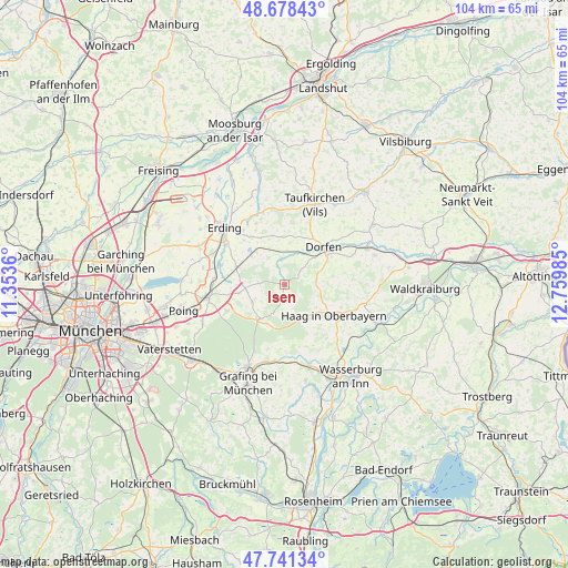
Isen GPS coordinates[2]
48° 12' 43.308" North, 12° 3' 24.192" East
| Map corner | latitude | longitude |
|---|---|---|
| Upper-left | 48.67843°, | 11.3536° |
| Center: | 48.21203°, | 12.05672° |
| Lower-right: | 47.74134°, | 12.75985° |
| Map W x H: | 104.2×104.2 km | = 64.7×64.7mi |
| max Lat: | 55.01917° ⇑92.5% North |
| Isen: | 48.21203° |
| min Lat: | ⇓7.5% South 47.40724° |
| min Long | Isen | max Long |
| 5.92978° | 12.05672° | 14.98853° |
| W 82.6%⇐ | ⇒17.4% E |
Elevation
Elevation of Isen is 519 m = 1703 ft, and this is 269.9 m = 885 ft above average elevation for this country.
| Max E: |
1256 m = 4121 ft | 9.6% |
| Isen | 519 m 1703 ft | |
| Avg. | 249.1 m = 817 ft | |
Min E: |
-5 m = -16 ft | 90.4% |
See also: Germany elevation on elevation.city.
Geographical zone
Isen is located in North temperate zone (between Tropic of Cancer and the Arctic Circle). Distance of this North polar circle is 2040.5 km =1267.9 mi to North.| Distance of | km | miles | from Isen |
|---|---|---|---|
| North Pole | 4646.4 | 2887.1 | to North |
| Arctic Circle | 2040.5 | 1267.9 | to North |
| Tropic Cancer | 2754.8 | 1711.8 | to South |
| Equator | 5360.7 | 3331 | to South |


Nearby cities:
15 places around Isen: (largest is in red/bold)
• Albaching
12 km =7.5 mi,  160°
160°
• Altdorf
11.5 km =7.1 mi,  124°
124°
• Buch am Buchrain
4.6 km =2.9 mi,  274°
274°
• Dorfen
10.1 km =6.3 mi,  49°
49°
• Forstern
6.7 km =4.2 mi,  241°
241°
• Forstinning
11.7 km =7.3 mi,  245°
245°
• Haag in Oberbayern
10.7 km =6.6 mi, 121°
• Hohenlinden
7.7 km =4.8 mi,  216°
216°
• Kirchdorf
11.1 km =6.9 mi,  111°
111°
• Lengdorf
5.1 km =3.2 mi,  354°
354°
• Maitenbeth
7.4 km =4.6 mi, 158°
• Pastetten
8.5 km =5.3 mi,  260°
260°
• Sankt Wolfgang
5.7 km =3.5 mi,  84°
84°
• Walpertskirchen
7.9 km =4.9 mi,  310°
310°
• Wörth
12 km =7.5 mi,  287°
287°
Sources, notices
• [Note1] Compared only with cities in Germany existing in our database
• [Src1] Map data: © OpenStreetMap contributors (CC-BY-SA)
• [Src2] Other city data from geonames.org with taken over terms of usage.
• [Src3] Geographical zone / Annual Mean Temperature by Robert A. Rohde @ Wikipedia
