Rückeroth geodata
Rückeroth (Rheinland-Pfalz) is a seat of a fourth-order administrative division; located in Germany in Europe/Berlin (GMT+2) time zone. With population of 494 people, there are 9393 cities with bigger population in this country. Compared to other cities in Germany, 51.4% of cities are located further ↑North; 82.2% of cities are located further →East and 60.2% of cities have lower elevation than Rückeroth. Note1


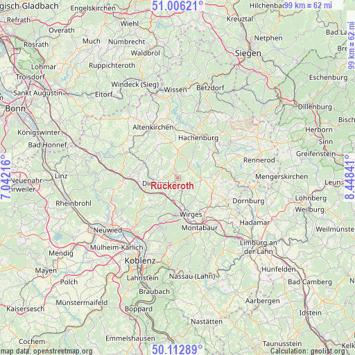
Rückeroth GPS coordinates[2]
50° 33' 42.012" North, 7° 44' 43.008" East
| Map corner | latitude | longitude |
|---|---|---|
| Upper-left | 51.00621°, | 7.04216° |
| Center: | 50.56167°, | 7.74528° |
| Lower-right: | 50.11289°, | 8.44841° |
| Map W x H: | 99.3×99.3 km | = 61.7×61.7mi |
| max Lat: | 55.01917° ⇑51.4% North |
| Rückeroth: | 50.56167° |
| min Lat: | ⇓48.6% South 47.40724° |
| min Long | Rückeroth | max Long |
| 5.92978° | 7.74528° | 14.98853° |
| W 17.8%⇐ | ⇒82.2% E |
Elevation
Elevation of Rückeroth is 291 m = 955 ft, and this is 41.9 m = 137 ft above average elevation for this country.
| Max E: |
1256 m = 4121 ft | 39.8% |
| Rückeroth | 291 m 955 ft | |
| Avg. | 249.1 m = 817 ft | |
Min E: |
-5 m = -16 ft | 60.2% |
See also: Germany elevation on elevation.city.
Geographical zone
Rückeroth is located in North temperate zone (between Tropic of Cancer and the Arctic Circle). Distance of this North polar circle is 1779.2 km =1105.5 mi to North.| Distance of | km | miles | from Rückeroth |
|---|---|---|---|
| North Pole | 4385.1 | 2724.8 | to North |
| Arctic Circle | 1779.2 | 1105.5 | to North |
| Tropic Cancer | 3016 | 1874.1 | to South |
| Equator | 5621.9 | 3493.3 | to South |


Nearby cities:
15 places around Rückeroth: (largest is in red/bold)
• Freirachdorf
3.1 km =1.9 mi,  320°
320°
• Goddert
1.4 km =0.9 mi,  175°
175°
• Hartenfels
3.3 km =2.1 mi,  65°
65°
• Herschbach
2.6 km =1.6 mi,  340°
340°
• Krümmel
3.1 km =1.9 mi,  208°
208°
• Marienhausen
3.7 km =2.3 mi,  273°
273°
• Marienrachdorf
2.4 km =1.5 mi,  237°
237°
• Maroth
4.3 km =2.7 mi,  293°
293°
• Maxsain
3.5 km =2.2 mi,  126°
126°
• Mündersbach
5 km =3.1 mi,  351°
351°
• Nordhofen
5 km =3.1 mi, 176°
• Schenkelberg
3.6 km =2.2 mi,  47°
47°
• Selters
3.3 km =2.1 mi,  167°
167°
• Sessenhausen
4.4 km =2.7 mi, 210°
• Steinen
4.6 km =2.9 mi,  58°
58°
Sources, notices
• [Note1] Compared only with cities in Germany existing in our database
• [Src1] Map data: © OpenStreetMap contributors (CC-BY-SA)
• [Src2] Other city data from geonames.org with taken over terms of usage.
• [Src3] Geographical zone / Annual Mean Temperature by Robert A. Rohde @ Wikipedia
