Rottenburg an der Laaber geodata
Rottenburg an der Laaber (Bavaria) is a populated place; located in Germany in Europe/Berlin (GMT+2) time zone. With population of 7,702 people, there are 2011 cities with bigger population in this country. Compared to other cities in Germany, 86.4% of cities are located further ↑North; 82.2% of cities are located further ←West and 82% of cities have lower elevation than Rottenburg an der Laaber. Note1
Administrative division(s):
- Level 1: Bavaria
- Level 2: Lower Bavaria
- Level 3: Landkreis Landshut
- Level 4: Rottenburg a.d.Laaber
Current local time in Rottenburg an der Laaber:
07:43 AM, SaturdayDifference from your time zone: hours


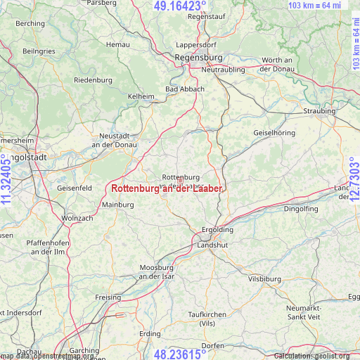
Rottenburg an der Laaber GPS coordinates[2]
48° 42' 8.388" North, 12° 1' 37.812" East
| Map corner | latitude | longitude |
|---|---|---|
| Upper-left | 49.16423°, | 11.32405° |
| Center: | 48.70233°, | 12.02717° |
| Lower-right: | 48.23615°, | 12.7303° |
| Map W x H: | 103.2×103.2 km | = 64.1×64.1mi |
| max Lat: | 55.01917° ⇑86.4% North |
| Rottenburg an der Laaber: | 48.70233° |
| min Lat: | ⇓13.6% South 47.40724° |
| min Long | Rottenburg an d | max Long |
| 5.92978° | 12.02717° | 14.98853° |
| W 82.2%⇐ | ⇒17.8% E |
Elevation
Elevation of Rottenburg an der Laaber is 446 m = 1463 ft, and this is 196.9 m = 646 ft above average elevation for this country.
| Max E: |
1256 m = 4121 ft | 18% |
| Rottenburg an der Laaber | 446 m 1463 ft | |
| Avg. | 249.1 m = 817 ft | |
Min E: |
-5 m = -16 ft | 82% |
See also: Germany elevation on elevation.city.
Geographical zone
Rottenburg an der Laaber is located in North temperate zone (between Tropic of Cancer and the Arctic Circle). Distance of this North polar circle is 1986 km =1234 mi to North.| Distance of | km | miles | from Rottenburg an der Laaber |
|---|---|---|---|
| North Pole | 4591.9 | 2853.3 | to North |
| Arctic Circle | 1986 | 1234 | to North |
| Tropic Cancer | 2809.3 | 1745.6 | to South |
| Equator | 5415.2 | 3364.8 | to South |


Nearby cities:
15 places around Rottenburg an der Laaber: (largest is in red/bold)
• Attenhofen
14.3 km =8.9 mi,  246°
246°
• Buch
11.4 km =7.1 mi,  119°
119°
• Ergoldsbach
13.1 km =8.1 mi,  94°
94°
• Furth
12.4 km =7.7 mi,  182°
182°
• Herrngiersdorf
10.1 km =6.3 mi,  18°
18°
• Hohenthann
6.6 km =4.1 mi,  133°
133°
• Kirchdorf
11.8 km =7.3 mi,  310°
310°
• Langquaid
13.6 km =8.5 mi,  7°
7°
• Obersüßbach
11.1 km =6.9 mi,  210°
210°
• Pfeffenhausen
6.1 km =3.8 mi,  227°
227°
• Rohr
8.3 km =5.2 mi,  330°
330°
• Siegenburg
14.3 km =8.9 mi,  293°
293°
• Train
14.6 km =9.1 mi,  283°
283°
• Weihmichl
11.5 km =7.1 mi,  171°
171°
• Wildenberg
9.9 km =6.2 mi, 287°
Sources, notices
• [Note1] Compared only with cities in Germany existing in our database
• [Src1] Map data: © OpenStreetMap contributors (CC-BY-SA)
• [Src2] Other city data from geonames.org with taken over terms of usage.
• [Src3] Geographical zone / Annual Mean Temperature by Robert A. Rohde @ Wikipedia
