Herrngiersdorf geodata
Herrngiersdorf (Bavaria) is a seat of a fourth-order administrative division; located in Germany in Europe/Berlin (GMT+2) time zone. With population of 1,103 people, there are 6837 cities with bigger population in this country. Compared to other cities in Germany, 85.5% of cities are located further ↑North; 82.8% of cities are located further ←West and 76.1% of cities have lower elevation than Herrngiersdorf. Note1
Administrative division(s):
- Level 1: Bavaria
- Level 2: Lower Bavaria
- Level 3: Landkreis Kelheim
- Level 4: Herrngiersdorf


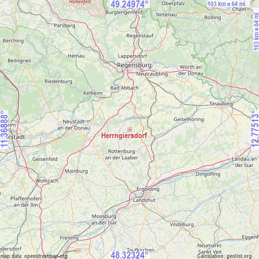
Herrngiersdorf GPS coordinates[2]
48° 47' 19.068" North, 12° 4' 19.2" East
| Map corner | latitude | longitude |
|---|---|---|
| Upper-left | 49.24974°, | 11.36888° |
| Center: | 48.78863°, | 12.072° |
| Lower-right: | 48.32324°, | 12.77513° |
| Map W x H: | 103×103 km | = 64×64mi |
| max Lat: | 55.01917° ⇑85.5% North |
| Herrngiersdorf: | 48.78863° |
| min Lat: | ⇓14.5% South 47.40724° |
| min Long | Herrngiersdorf | max Long |
| 5.92978° | 12.072° | 14.98853° |
| W 82.8%⇐ | ⇒17.2% E |
Elevation
Elevation of Herrngiersdorf is 406 m = 1332 ft, and this is 156.9 m = 515 ft above average elevation for this country.
| Max E: |
1256 m = 4121 ft | 23.9% |
| Herrngiersdorf | 406 m 1332 ft | |
| Avg. | 249.1 m = 817 ft | |
Min E: |
-5 m = -16 ft | 76.1% |
See also: Germany elevation on elevation.city.
Geographical zone
Herrngiersdorf is located in North temperate zone (between Tropic of Cancer and the Arctic Circle). Distance of this North polar circle is 1976.4 km =1228.1 mi to North.| Distance of | km | miles | from Herrngiersdorf |
|---|---|---|---|
| North Pole | 4582.3 | 2847.3 | to North |
| Arctic Circle | 1976.4 | 1228.1 | to North |
| Tropic Cancer | 2818.9 | 1751.6 | to South |
| Equator | 5424.8 | 3370.8 | to South |


Nearby cities:
15 places around Herrngiersdorf: (largest is in red/bold)
• Biburg
15.7 km =9.8 mi,  270°
270°
• Ergoldsbach
14.4 km =8.9 mi,  137°
137°
• Hausen
9.2 km =5.7 mi,  328°
328°
• Hohenthann
14.3 km =8.9 mi,  173°
173°
• Kirchdorf
12.5 km =7.8 mi,  260°
260°
• Langquaid
4.1 km =2.5 mi,  338°
338°
• Mallersdorf-Pfaffenberg
11.9 km =7.4 mi,  101°
101°
• Pfakofen
13.8 km =8.6 mi,  55°
55°
• Pfeffenhausen
15.8 km =9.8 mi,  209°
209°
• Rohr
7.7 km =4.8 mi,  252°
252°
• Rottenburg an der Laaber
10.1 km =6.3 mi,  198°
198°
• Schierling
7.1 km =4.4 mi,  44°
44°
• Teugn
12.4 km =7.7 mi, 339°
• Thalmassing
15 km =9.3 mi,  23°
23°
• Wildenberg
14.3 km =8.9 mi,  242°
242°
Sources, notices
• [Note1] Compared only with cities in Germany existing in our database
• [Src1] Map data: © OpenStreetMap contributors (CC-BY-SA)
• [Src2] Other city data from geonames.org with taken over terms of usage.
• [Src3] Geographical zone / Annual Mean Temperature by Robert A. Rohde @ Wikipedia
