Rohr geodata
Rohr (Bavaria) is a populated place; located in Germany in Europe/Berlin (GMT+2) time zone. With population of 3,357 people, there are 3716 cities with bigger population in this country. Compared to other cities in Germany, 85.7% of cities are located further ↑North; 81.4% of cities are located further ←West and 78.8% of cities have lower elevation than Rohr. Note1
Administrative division(s):
- Level 1: Bavaria
- Level 2: Lower Bavaria
- Level 3: Landkreis Kelheim
- Level 4: Rohr i.NB, Markt


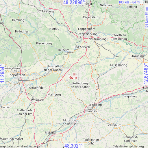
Rohr GPS coordinates[2]
48° 46' 3.648" North, 11° 58' 17.472" East
| Map corner | latitude | longitude |
|---|---|---|
| Upper-left | 49.22898°, | 11.2684° |
| Center: | 48.76768°, | 11.97152° |
| Lower-right: | 48.3021°, | 12.67465° |
| Map W x H: | 103.1×103.1 km | = 64.1×64.1mi |
| max Lat: | 55.01917° ⇑85.7% North |
| Rohr: | 48.76768° |
| min Lat: | ⇓14.3% South 47.40724° |
| min Long | Rohr | max Long |
| 5.92978° | 11.97152° | 14.98853° |
| W 81.4%⇐ | ⇒18.6% E |
Elevation
Elevation of Rohr is 425 m = 1394 ft, and this is 175.9 m = 577 ft above average elevation for this country.
| Max E: |
1256 m = 4121 ft | 21.2% |
| Rohr | 425 m 1394 ft | |
| Avg. | 249.1 m = 817 ft | |
Min E: |
-5 m = -16 ft | 78.8% |
See also: Germany elevation on elevation.city.
Geographical zone
Rohr is located in North temperate zone (between Tropic of Cancer and the Arctic Circle). Distance of this North polar circle is 1978.7 km =1229.5 mi to North.| Distance of | km | miles | from Rohr |
|---|---|---|---|
| North Pole | 4584.6 | 2848.7 | to North |
| Arctic Circle | 1978.7 | 1229.5 | to North |
| Tropic Cancer | 2816.5 | 1750.1 | to South |
| Equator | 5422.5 | 3369.4 | to South |


Nearby cities:
15 places around Rohr: (largest is in red/bold)
• Abensberg
10.5 km =6.5 mi,  301°
301°
• Biburg
8.8 km =5.5 mi,  286°
286°
• Elsendorf
13.6 km =8.5 mi,  240°
240°
• Hausen
10.5 km =6.5 mi,  14°
14°
• Herrngiersdorf
7.7 km =4.8 mi,  72°
72°
• Hohenthann
14.8 km =9.2 mi,  143°
143°
• Kirchdorf
5 km =3.1 mi,  274°
274°
• Langquaid
8.5 km =5.3 mi,  43°
43°
• Pfeffenhausen
11.5 km =7.1 mi,  182°
182°
• Rottenburg an der Laaber
8.3 km =5.2 mi,  150°
150°
• Schierling
14.4 km =8.9 mi,  58°
58°
• Siegenburg
9.2 km =5.7 mi,  260°
260°
• Teugn
14.2 km =8.8 mi, 11°
• Train
10.8 km =6.7 mi,  249°
249°
• Wildenberg
6.8 km =4.2 mi,  231°
231°
Sources, notices
• [Note1] Compared only with cities in Germany existing in our database
• [Src1] Map data: © OpenStreetMap contributors (CC-BY-SA)
• [Src2] Other city data from geonames.org with taken over terms of usage.
• [Src3] Geographical zone / Annual Mean Temperature by Robert A. Rohde @ Wikipedia
