Langquaid geodata
Langquaid (Bavaria) is a populated place; located in Germany in Europe/Berlin (GMT+2) time zone. With population of 5,159 people, there are 2764 cities with bigger population in this country. Compared to other cities in Germany, 85.1% of cities are located further ↑North; 82.5% of cities are located further ←West and 73.9% of cities have lower elevation than Langquaid. Note1
Administrative division(s):
- Level 1: Bavaria
- Level 2: Lower Bavaria
- Level 3: Landkreis Kelheim
- Level 4: Langquaid, Markt


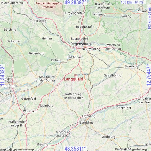
Langquaid GPS coordinates[2]
48° 49' 23.448" North, 12° 3' 4.824" East
| Map corner | latitude | longitude |
|---|---|---|
| Upper-left | 49.28397°, | 11.34822° |
| Center: | 48.82318°, | 12.05134° |
| Lower-right: | 48.35811°, | 12.75447° |
| Map W x H: | 102.9×102.9 km | = 63.9×63.9mi |
| max Lat: | 55.01917° ⇑85.1% North |
| Langquaid: | 48.82318° |
| min Lat: | ⇓14.9% South 47.40724° |
| min Long | Langquaid | max Long |
| 5.92978° | 12.05134° | 14.98853° |
| W 82.5%⇐ | ⇒17.5% E |
Elevation
Elevation of Langquaid is 389 m = 1276 ft, and this is 139.9 m = 459 ft above average elevation for this country.
| Max E: |
1256 m = 4121 ft | 26.1% |
| Langquaid | 389 m 1276 ft | |
| Avg. | 249.1 m = 817 ft | |
Min E: |
-5 m = -16 ft | 73.9% |
See also: Germany elevation on elevation.city.
Geographical zone
Langquaid is located in North temperate zone (between Tropic of Cancer and the Arctic Circle). Distance of this North polar circle is 1972.5 km =1225.7 mi to North.| Distance of | km | miles | from Langquaid |
|---|---|---|---|
| North Pole | 4578.4 | 2844.9 | to North |
| Arctic Circle | 1972.5 | 1225.7 | to North |
| Tropic Cancer | 2822.7 | 1753.9 | to South |
| Equator | 5428.6 | 3373.2 | to South |


Nearby cities:
15 places around Langquaid: (largest is in red/bold)
• Abensberg
14.8 km =9.2 mi,  267°
267°
• Bad Abbach
12.7 km =7.9 mi,  357°
357°
• Biburg
14.7 km =9.1 mi,  255°
255°
• Hagelstadt
14.8 km =9.2 mi,  54°
54°
• Hausen
5.2 km =3.2 mi,  320°
320°
• Herrngiersdorf
4.1 km =2.5 mi,  158°
158°
• Kirchdorf
12.3 km =7.6 mi,  241°
241°
• Mallersdorf-Pfaffenberg
14.6 km =9.1 mi,  115°
115°
• Pfakofen
13.5 km =8.4 mi,  73°
73°
• Rohr
8.5 km =5.3 mi,  223°
223°
• Rottenburg an der Laaber
13.6 km =8.5 mi,  187°
187°
• Saal
12.3 km =7.6 mi,  314°
314°
• Schierling
6.6 km =4.1 mi,  79°
79°
• Teugn
8.3 km =5.2 mi,  339°
339°
• Thalmassing
12.4 km =7.7 mi,  37°
37°
Sources, notices
• [Note1] Compared only with cities in Germany existing in our database
• [Src1] Map data: © OpenStreetMap contributors (CC-BY-SA)
• [Src2] Other city data from geonames.org with taken over terms of usage.
• [Src3] Geographical zone / Annual Mean Temperature by Robert A. Rohde @ Wikipedia
