Rösa geodata
Rösa (Saxony-Anhalt) is a populated place; located in Germany in Europe/Berlin (GMT+2) time zone. With population of 923 people, there are 7444 cities with bigger population in this country. Compared to other cities in Germany, 67.9% of cities are located further ↓South; 87.9% of cities are located further ←West and 69.2% of cities have higher elevation than Rösa. Note1


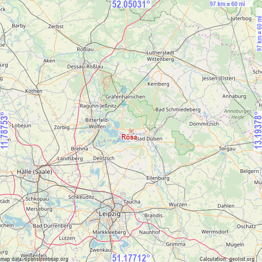
Rösa GPS coordinates[2]
51° 36' 56.916" North, 12° 29' 26.34" East
| Map corner | latitude | longitude |
|---|---|---|
| Upper-left | 52.05031°, | 11.78753° |
| Center: | 51.61581°, | 12.49065° |
| Lower-right: | 51.17712°, | 13.19378° |
| Map W x H: | 97.1×97.1 km | = 60.3×60.3mi |
| max Lat: | 55.01917° ⇑32.1% North |
| Rösa: | 51.61581° |
| min Lat: | ⇓67.9% South 47.40724° |
| min Long | Rösa | max Long |
| 5.92978° | 12.49065° | 14.98853° |
| W 87.9%⇐ | ⇒12.1% E |
Elevation
Elevation of Rösa is 96 m = 315 ft, and this is 153.1 m = 502 ft below average elevation for this country.
| Max E: |
1256 m = 4121 ft | 69.2% |
| Avg. | 249.1 m = 817 ft | |
| Rösa | 96 m = 315 ft | |
Min E: |
-5 m = -16 ft | 30.8% |
See also: Germany elevation on elevation.city.
Geographical zone
Rösa is located in North temperate zone (between Tropic of Cancer and the Arctic Circle). Distance of this North polar circle is 1662 km =1032.7 mi to North.| Distance of | km | miles | from Rösa |
|---|---|---|---|
| North Pole | 4267.9 | 2651.9 | to North |
| Arctic Circle | 1662 | 1032.7 | to North |
| Tropic Cancer | 3133.2 | 1946.9 | to South |
| Equator | 5739.1 | 3566.1 | to South |


Nearby cities:
15 places around Rösa: (largest is in red/bold)
• Bad Düben
7 km =4.3 mi,  112°
112°
• Bitterfeld-Wolfen
11.5 km =7.1 mi,  274°
274°
• Burgkemnitz
9.8 km =6.1 mi,  320°
320°
• Friedersdorf
9.4 km =5.8 mi,  292°
292°
• Gossa
6.8 km =4.2 mi,  331°
331°
• Gröbern
8.5 km =5.3 mi,  341°
341°
• Krina
4.3 km =2.7 mi,  356°
356°
• Löbnitz
3.2 km =2 mi,  215°
215°
• Muldenstein
11.8 km =7.3 mi,  301°
301°
• Mühlbeck
8 km =5 mi, 288°
• Pouch
6.2 km =3.9 mi,  277°
277°
• Schköna
7.9 km =4.9 mi,  23°
23°
• Schlaitz
6.4 km =4 mi, 317°
• Schwemsal
4.7 km =2.9 mi,  74°
74°
• Söllichau
11 km =6.8 mi,  78°
78°
Sources, notices
• [Note1] Compared only with cities in Germany existing in our database
• [Src1] Map data: © OpenStreetMap contributors (CC-BY-SA)
• [Src2] Other city data from geonames.org with taken over terms of usage.
• [Src3] Geographical zone / Annual Mean Temperature by Robert A. Rohde @ Wikipedia
