Bad Düben geodata
Bad Düben (Saxony) is a populated place; located in Germany in Europe/Berlin (GMT+2) time zone. With population of 8,998 people, there are 1791 cities with bigger population in this country. Compared to other cities in Germany, 67.5% of cities are located further ↓South; 88.7% of cities are located further ←West and 70% of cities have higher elevation than Bad Düben. Note1


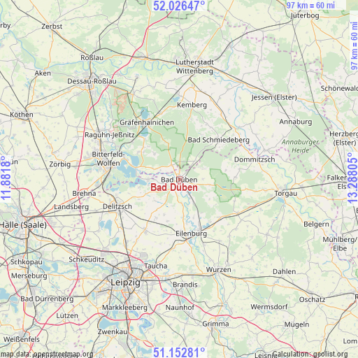
Bad Düben GPS coordinates[2]
51° 35' 30.264" North, 12° 35' 5.712" East
| Map corner | latitude | longitude |
|---|---|---|
| Upper-left | 52.02647°, | 11.8818° |
| Center: | 51.59174°, | 12.58492° |
| Lower-right: | 51.15281°, | 13.28805° |
| Map W x H: | 97.1×97.1 km | = 60.3×60.3mi |
| max Lat: | 55.01917° ⇑32.5% North |
| Bad Düben: | 51.59174° |
| min Lat: | ⇓67.5% South 47.40724° |
| min Long | Bad Düben | max Long |
| 5.92978° | 12.58492° | 14.98853° |
| W 88.7%⇐ | ⇒11.3% E |
Elevation
Elevation of Bad Düben is 91 m = 299 ft, and this is 158.1 m = 519 ft below average elevation for this country.
| Max E: |
1256 m = 4121 ft | 70% |
| Avg. | 249.1 m = 817 ft | |
| Bad Düben | 91 m = 299 ft | |
Min E: |
-5 m = -16 ft | 30% |
See also: Germany elevation on elevation.city.
Geographical zone
Bad Düben is located in North temperate zone (between Tropic of Cancer and the Arctic Circle). Distance of this North polar circle is 1664.7 km =1034.4 mi to North.| Distance of | km | miles | from Bad Düben |
|---|---|---|---|
| North Pole | 4270.6 | 2653.6 | to North |
| Arctic Circle | 1664.7 | 1034.4 | to North |
| Tropic Cancer | 3130.5 | 1945.2 | to South |
| Equator | 5736.5 | 3564.5 | to South |


Nearby cities:
15 places around Bad Düben: (largest is in red/bold)
• Bad Schmiedeberg
14.7 km =9.1 mi,  44°
44°
• Eilenburg
15 km =9.3 mi,  167°
167°
• Gossa
13 km =8.1 mi,  311°
311°
• Gröbern
14.2 km =8.8 mi,  319°
319°
• Kossa
7.3 km =4.5 mi,  67°
67°
• Krina
9.7 km =6 mi, 316°
• Laußig
5.9 km =3.7 mi,  148°
148°
• Löbnitz
8.4 km =5.2 mi,  270°
270°
• Pouch
13.2 km =8.2 mi,  285°
285°
• Rösa
7 km =4.3 mi, 292°
• Schköna
10.5 km =6.5 mi,  341°
341°
• Schlaitz
13.1 km =8.1 mi,  304°
304°
• Schwemsal
4.4 km =2.7 mi,  333°
333°
• Söllichau
6.5 km =4 mi, 41°
• Zschepplin
10.3 km =6.4 mi, 174°
Sources, notices
• [Note1] Compared only with cities in Germany existing in our database
• [Src1] Map data: © OpenStreetMap contributors (CC-BY-SA)
• [Src2] Other city data from geonames.org with taken over terms of usage.
• [Src3] Geographical zone / Annual Mean Temperature by Robert A. Rohde @ Wikipedia
