Rodenberg geodata
Rodenberg (Lower Saxony) is a populated place; located in Germany in Europe/Berlin (GMT+2) time zone. With population of 6,258 people, there are 2382 cities with bigger population in this country. Compared to other cities in Germany, 75.3% of cities are located further ↓South; 60% of cities are located further →East and 73.2% of cities have higher elevation than Rodenberg. Note1


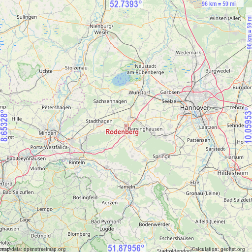
Rodenberg GPS coordinates[2]
52° 18' 41.472" North, 9° 21' 23.04" East
| Map corner | latitude | longitude |
|---|---|---|
| Upper-left | 52.7393°, | 8.65328° |
| Center: | 52.31152°, | 9.3564° |
| Lower-right: | 51.87956°, | 10.05953° |
| Map W x H: | 95.6×95.6 km | = 59.4×59.4mi |
| max Lat: | 55.01917° ⇑24.7% North |
| Rodenberg: | 52.31152° |
| min Lat: | ⇓75.3% South 47.40724° |
| min Long | Rodenberg | max Long |
| 5.92978° | 9.3564° | 14.98853° |
| W 40%⇐ | ⇒60% E |
Elevation
Elevation of Rodenberg is 71 m = 233 ft, and this is 178.1 m = 584 ft below average elevation for this country.
| Max E: |
1256 m = 4121 ft | 73.2% |
| Avg. | 249.1 m = 817 ft | |
| Rodenberg | 71 m = 233 ft | |
Min E: |
-5 m = -16 ft | 26.8% |
See also: Germany elevation on elevation.city.
Geographical zone
Rodenberg is located in North temperate zone (between Tropic of Cancer and the Arctic Circle). Distance of this North polar circle is 1584.7 km =984.7 mi to North.| Distance of | km | miles | from Rodenberg |
|---|---|---|---|
| North Pole | 4190.6 | 2603.9 | to North |
| Arctic Circle | 1584.7 | 984.7 | to North |
| Tropic Cancer | 3210.6 | 1995 | to South |
| Equator | 5816.5 | 3614.2 | to South |


Nearby cities:
15 places around Rodenberg: (largest is in red/bold)
• Apelern
2.8 km =1.7 mi,  210°
210°
• Bad Nenndorf
3.2 km =2 mi,  28°
28°
• Barsinghausen
6.5 km =4 mi,  101°
101°
• Beckedorf
5.1 km =3.2 mi,  327°
327°
• Groß Munzel
10.2 km =6.3 mi,  54°
54°
• Großgoltern
10.1 km =6.3 mi,  76°
76°
• Haste
8.1 km =5 mi,  17°
17°
• Heuerßen
5.7 km =3.5 mi,  290°
290°
• Hohnhorst
6.5 km =4 mi,  9°
9°
• Hülsede
6.9 km =4.3 mi,  177°
177°
• Lauenau
4.3 km =2.7 mi,  168°
168°
• Lindhorst
7.2 km =4.5 mi,  316°
316°
• Lüdersfeld
8.8 km =5.5 mi,  307°
307°
• Messenkamp
6 km =3.7 mi,  164°
164°
• Pohle
5.1 km =3.2 mi,  189°
189°
Sources, notices
• [Note1] Compared only with cities in Germany existing in our database
• [Src1] Map data: © OpenStreetMap contributors (CC-BY-SA)
• [Src2] Other city data from geonames.org with taken over terms of usage.
• [Src3] Geographical zone / Annual Mean Temperature by Robert A. Rohde @ Wikipedia
