Apelern geodata
Apelern (Lower Saxony) is a seat of a fourth-order administrative division; located in Germany in Europe/Berlin (GMT+2) time zone. With population of 2,673 people, there are 4257 cities with bigger population in this country. Compared to other cities in Germany, 75.1% of cities are located further ↓South; 60.2% of cities are located further →East and 69.4% of cities have higher elevation than Apelern. Note1


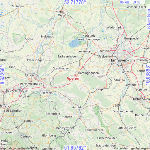
Apelern GPS coordinates[2]
52° 17' 23.244" North, 9° 20' 8.88" East
| Map corner | latitude | longitude |
|---|---|---|
| Upper-left | 52.71778°, | 8.63268° |
| Center: | 52.28979°, | 9.3358° |
| Lower-right: | 51.85762°, | 10.03893° |
| Map W x H: | 95.6×95.6 km | = 59.4×59.4mi |
| max Lat: | 55.01917° ⇑24.9% North |
| Apelern: | 52.28979° |
| min Lat: | ⇓75.1% South 47.40724° |
| min Long | Apelern | max Long |
| 5.92978° | 9.3358° | 14.98853° |
| W 39.8%⇐ | ⇒60.2% E |
Elevation
Elevation of Apelern is 95 m = 312 ft, and this is 154.1 m = 506 ft below average elevation for this country.
| Max E: |
1256 m = 4121 ft | 69.4% |
| Avg. | 249.1 m = 817 ft | |
| Apelern | 95 m = 312 ft | |
Min E: |
-5 m = -16 ft | 30.6% |
See also: Germany elevation on elevation.city.
Geographical zone
Apelern is located in North temperate zone (between Tropic of Cancer and the Arctic Circle). Distance of this North polar circle is 1587.1 km =986.2 mi to North.| Distance of | km | miles | from Apelern |
|---|---|---|---|
| North Pole | 4193 | 2605.4 | to North |
| Arctic Circle | 1587.1 | 986.2 | to North |
| Tropic Cancer | 3208.2 | 1993.5 | to South |
| Equator | 5814.1 | 3612.7 | to South |


Nearby cities:
15 places around Apelern: (largest is in red/bold)
• Bad Nenndorf
6 km =3.7 mi,  29°
29°
• Barsinghausen
7.8 km =4.8 mi,  81°
81°
• Beckedorf
6.8 km =4.2 mi,  349°
349°
• Haste
10.9 km =6.8 mi,  20°
20°
• Heuerßen
5.9 km =3.7 mi,  317°
317°
• Hohnhorst
9.2 km =5.7 mi, 15°
• Hülsede
4.8 km =3 mi,  158°
158°
• Lauenau
2.9 km =1.8 mi,  127°
127°
• Lindhorst
8.4 km =5.2 mi,  334°
334°
• Lüdersfeld
9.6 km =6 mi, 324°
• Messenkamp
4.5 km =2.8 mi,  137°
137°
• Pohle
2.7 km =1.7 mi,  167°
167°
• Rehren
9.4 km =5.8 mi,  228°
228°
• Rodenberg
2.8 km =1.7 mi, 30°
• Stadthagen
9.8 km =6.1 mi,  292°
292°
Sources, notices
• [Note1] Compared only with cities in Germany existing in our database
• [Src1] Map data: © OpenStreetMap contributors (CC-BY-SA)
• [Src2] Other city data from geonames.org with taken over terms of usage.
• [Src3] Geographical zone / Annual Mean Temperature by Robert A. Rohde @ Wikipedia
