Hohnhorst geodata
Hohnhorst (Lower Saxony) is a seat of a fourth-order administrative division; located in Germany in Europe/Berlin (GMT+2) time zone. With population of 2,262 people, there are 4723 cities with bigger population in this country. Compared to other cities in Germany, 75.9% of cities are located further ↓South; 59.7% of cities are located further →East and 75.3% of cities have higher elevation than Hohnhorst. Note1


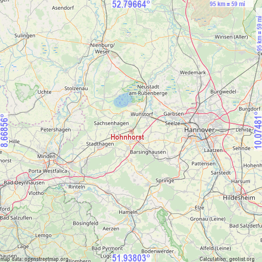
Hohnhorst GPS coordinates[2]
52° 22' 9.912" North, 9° 22' 18.048" East
| Map corner | latitude | longitude |
|---|---|---|
| Upper-left | 52.79664°, | 8.66856° |
| Center: | 52.36942°, | 9.37168° |
| Lower-right: | 51.93803°, | 10.07481° |
| Map W x H: | 95.5×95.5 km | = 59.3×59.3mi |
| max Lat: | 55.01917° ⇑24.1% North |
| Hohnhorst: | 52.36942° |
| min Lat: | ⇓75.9% South 47.40724° |
| min Long | Hohnhorst | max Long |
| 5.92978° | 9.37168° | 14.98853° |
| W 40.3%⇐ | ⇒59.7% E |
Elevation
Elevation of Hohnhorst is 62 m = 203 ft, and this is 187.1 m = 614 ft below average elevation for this country.
| Max E: |
1256 m = 4121 ft | 75.3% |
| Avg. | 249.1 m = 817 ft | |
| Hohnhorst | 62 m = 203 ft | |
Min E: |
-5 m = -16 ft | 24.7% |
See also: Germany elevation on elevation.city.
Geographical zone
Hohnhorst is located in North temperate zone (between Tropic of Cancer and the Arctic Circle). Distance of this North polar circle is 1578.2 km =980.6 mi to North.| Distance of | km | miles | from Hohnhorst |
|---|---|---|---|
| North Pole | 4184.1 | 2599.9 | to North |
| Arctic Circle | 1578.2 | 980.6 | to North |
| Tropic Cancer | 3217 | 1999 | to South |
| Equator | 5822.9 | 3618.2 | to South |


Nearby cities:
15 places around Hohnhorst: (largest is in red/bold)
• Apelern
9.2 km =5.7 mi,  195°
195°
• Auhagen
6.3 km =3.9 mi,  300°
300°
• Bad Nenndorf
3.6 km =2.2 mi,  172°
172°
• Barsinghausen
9.4 km =5.8 mi,  145°
145°
• Beckedorf
4.3 km =2.7 mi,  239°
239°
• Groß Munzel
7.3 km =4.5 mi,  93°
93°
• Großgoltern
9.7 km =6 mi,  114°
114°
• Hagenburg
7.8 km =4.8 mi,  335°
335°
• Haste
1.9 km =1.2 mi,  47°
47°
• Heuerßen
7.8 km =4.8 mi, 235°
• Lindhorst
6.1 km =3.8 mi,  257°
257°
• Lüdersfeld
8 km =5 mi, 262°
• Rodenberg
6.5 km =4 mi,  189°
189°
• Sachsenhagen
7.7 km =4.8 mi,  293°
293°
• Wunstorf
7.4 km =4.6 mi,  35°
35°
Sources, notices
• [Note1] Compared only with cities in Germany existing in our database
• [Src1] Map data: © OpenStreetMap contributors (CC-BY-SA)
• [Src2] Other city data from geonames.org with taken over terms of usage.
• [Src3] Geographical zone / Annual Mean Temperature by Robert A. Rohde @ Wikipedia
