Pohle geodata
Pohle (Lower Saxony) is a seat of a fourth-order administrative division; located in Germany in Europe/Berlin (GMT+2) time zone. With population of 956 people, there are 7323 cities with bigger population in this country. Compared to other cities in Germany, 74.8% of cities are located further ↓South; 60.1% of cities are located further →East and 68.3% of cities have higher elevation than Pohle. Note1


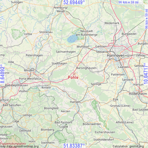
Pohle GPS coordinates[2]
52° 15' 58.572" North, 9° 20' 38.544" East
| Map corner | latitude | longitude |
|---|---|---|
| Upper-left | 52.69449°, | 8.64092° |
| Center: | 52.26627°, | 9.34404° |
| Lower-right: | 51.83387°, | 10.04717° |
| Map W x H: | 95.7×95.7 km | = 59.5×59.5mi |
| max Lat: | 55.01917° ⇑25.2% North |
| Pohle: | 52.26627° |
| min Lat: | ⇓74.8% South 47.40724° |
| min Long | Pohle | max Long |
| 5.92978° | 9.34404° | 14.98853° |
| W 39.9%⇐ | ⇒60.1% E |
Elevation
Elevation of Pohle is 101 m = 331 ft, and this is 148.1 m = 486 ft below average elevation for this country.
| Max E: |
1256 m = 4121 ft | 68.3% |
| Avg. | 249.1 m = 817 ft | |
| Pohle | 101 m = 331 ft | |
Min E: |
-5 m = -16 ft | 31.7% |
See also: Germany elevation on elevation.city.
Geographical zone
Pohle is located in North temperate zone (between Tropic of Cancer and the Arctic Circle). Distance of this North polar circle is 1589.7 km =987.8 mi to North.| Distance of | km | miles | from Pohle |
|---|---|---|---|
| North Pole | 4195.6 | 2607 | to North |
| Arctic Circle | 1589.7 | 987.8 | to North |
| Tropic Cancer | 3205.5 | 1991.8 | to South |
| Equator | 5811.5 | 3611.1 | to South |


Nearby cities:
15 places around Pohle: (largest is in red/bold)
• Apelern
2.7 km =1.7 mi,  347°
347°
• Bad Münder am Deister
11.4 km =7.1 mi,  133°
133°
• Bad Nenndorf
8.2 km =5.1 mi,  16°
16°
• Barsinghausen
8.1 km =5 mi,  62°
62°
• Beckedorf
9.5 km =5.9 mi, 348°
• Egestorf
11.9 km =7.4 mi,  79°
79°
• Heuerßen
8.4 km =5.2 mi,  327°
327°
• Hohnhorst
11.6 km =7.2 mi,  9°
9°
• Hülsede
2.2 km =1.4 mi,  147°
147°
• Lauenau
1.9 km =1.2 mi, 63°
• Lindhorst
11 km =6.8 mi,  337°
337°
• Messenkamp
2.6 km =1.6 mi,  105°
105°
• Rehren
8.4 km =5.2 mi,  244°
244°
• Rodenberg
5.1 km =3.2 mi, 9°
• Stadthagen
11.5 km =7.1 mi,  303°
303°
Sources, notices
• [Note1] Compared only with cities in Germany existing in our database
• [Src1] Map data: © OpenStreetMap contributors (CC-BY-SA)
• [Src2] Other city data from geonames.org with taken over terms of usage.
• [Src3] Geographical zone / Annual Mean Temperature by Robert A. Rohde @ Wikipedia
