Rimschweiler geodata
Rimschweiler (Rheinland-Pfalz) is a populated place; located in Germany in Europe/Berlin (GMT+2) time zone. With population of 1,930 people, there are 5167 cities with bigger population in this country. Compared to other cities in Germany, 80.1% of cities are located further ↑North; 88.9% of cities are located further →East and 51.7% of cities have lower elevation than Rimschweiler. Note1
Administrative division(s):
- Level 1: Rheinland-Pfalz
- Level 3: Kreisfreie Stadt Zweibrücken
- Level 4: Zweibrücken


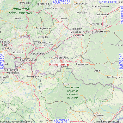
Rimschweiler GPS coordinates[2]
49° 13' 7.68" North, 7° 22' 32.556" East
| Map corner | latitude | longitude |
|---|---|---|
| Upper-left | 49.67593°, | 6.67259° |
| Center: | 49.2188°, | 7.37571° |
| Lower-right: | 48.7574°, | 8.07884° |
| Map W x H: | 102.1×102.1 km | = 63.4×63.4mi |
| max Lat: | 55.01917° ⇑80.1% North |
| Rimschweiler: | 49.2188° |
| min Lat: | ⇓19.9% South 47.40724° |
| min Long | Rimschweiler | max Long |
| 5.92978° | 7.37571° | 14.98853° |
| W 11.1%⇐ | ⇒88.9% E |
Elevation
Elevation of Rimschweiler is 238 m = 781 ft, and this is 11.1 m = 36 ft below average elevation for this country.
| Max E: |
1256 m = 4121 ft | 48.3% |
| Avg. | 249.1 m = 817 ft | |
| Rimschweiler | 238 m = 781 ft | |
Min E: |
-5 m = -16 ft | 51.7% |
See also: Germany elevation on elevation.city.
Geographical zone
Rimschweiler is located in North temperate zone (between Tropic of Cancer and the Arctic Circle). Distance of this North polar circle is 1928.6 km =1198.4 mi to North.| Distance of | km | miles | from Rimschweiler |
|---|---|---|---|
| North Pole | 4534.4 | 2817.5 | to North |
| Arctic Circle | 1928.6 | 1198.4 | to North |
| Tropic Cancer | 2866.7 | 1781.3 | to South |
| Equator | 5472.6 | 3400.5 | to South |


Nearby cities:
15 places around Rimschweiler: (largest is in red/bold)
• Althornbach
1.7 km =1.1 mi,  181°
181°
• Battweiler
9.2 km =5.7 mi,  43°
43°
• Blieskastel
8.9 km =5.5 mi,  283°
283°
• Contwig
5.4 km =3.4 mi,  50°
50°
• Dellfeld
7.3 km =4.5 mi,  76°
76°
• Dietrichingen
4.9 km =3 mi,  142°
142°
• Großbundenbach
9.5 km =5.9 mi,  18°
18°
• Großsteinhausen
6.7 km =4.2 mi,  126°
126°
• Hornbach
3.5 km =2.2 mi,  188°
188°
• Kleinsteinhausen
6.9 km =4.3 mi,  107°
107°
• Mauschbach
4.3 km =2.7 mi,  155°
155°
• Riedelberg
6.7 km =4.2 mi, 126°
• Rieschweiler-Mühlbach
9.2 km =5.7 mi, 79°
• Walshausen
7.8 km =4.8 mi,  91°
91°
• Zweibrücken
3.1 km =1.9 mi,  352°
352°
Sources, notices
• [Note1] Compared only with cities in Germany existing in our database
• [Src1] Map data: © OpenStreetMap contributors (CC-BY-SA)
• [Src2] Other city data from geonames.org with taken over terms of usage.
• [Src3] Geographical zone / Annual Mean Temperature by Robert A. Rohde @ Wikipedia
