Zweibrücken geodata
Zweibrücken (Rheinland-Pfalz) is a seat of a third-order administrative division; located in Germany in Europe/Berlin (GMT+2) time zone. With population of 35,221 people, there are 380 cities with bigger population in this country. Compared to other cities in Germany, 79.6% of cities are located further ↑North; 88.9% of cities are located further →East and 52.3% of cities have lower elevation than Zweibrücken. Note1
Administrative division(s):
- Level 1: Rheinland-Pfalz
- Level 3: Kreisfreie Stadt Zweibrücken
- Level 4: Zweibrücken


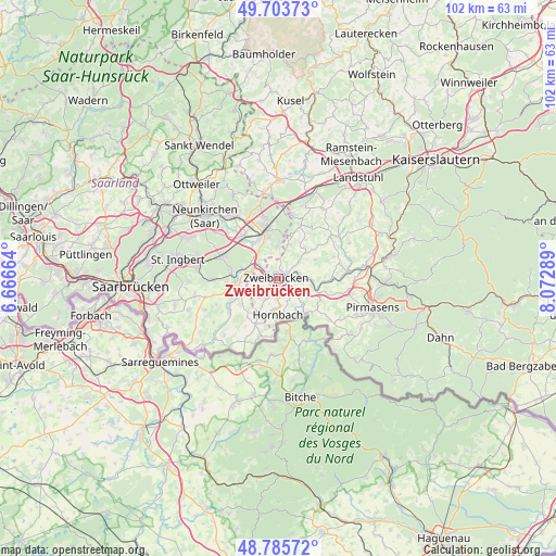
Zweibrücken GPS coordinates[2]
49° 14' 48.696" North, 7° 22' 11.172" East
| Map corner | latitude | longitude |
|---|---|---|
| Upper-left | 49.70373°, | 6.66664° |
| Center: | 49.24686°, | 7.36977° |
| Lower-right: | 48.78572°, | 8.07289° |
| Map W x H: | 102.1×102.1 km | = 63.4×63.4mi |
| max Lat: | 55.01917° ⇑79.6% North |
| Zweibrücken: | 49.24686° |
| min Lat: | ⇓20.4% South 47.40724° |
| min Long | Zweibrücken | max Long |
| 5.92978° | 7.36977° | 14.98853° |
| W 11.1%⇐ | ⇒88.9% E |
Elevation
Elevation of Zweibrücken is 242 m = 794 ft, and this is 7.1 m = 23 ft below average elevation for this country.
| Max E: |
1256 m = 4121 ft | 47.7% |
| Avg. | 249.1 m = 817 ft | |
| Zweibrücken | 242 m = 794 ft | |
Min E: |
-5 m = -16 ft | 52.3% |
See also: Germany elevation on elevation.city.
Geographical zone
Zweibrücken is located in North temperate zone (between Tropic of Cancer and the Arctic Circle). Distance of this North polar circle is 1925.4 km =1196.4 mi to North.| Distance of | km | miles | from Zweibrücken |
|---|---|---|---|
| North Pole | 4531.3 | 2815.6 | to North |
| Arctic Circle | 1925.4 | 1196.4 | to North |
| Tropic Cancer | 2869.8 | 1783.2 | to South |
| Equator | 5475.7 | 3402.4 | to South |


Nearby cities:
15 places around Zweibrücken: (largest is in red/bold)
• Althornbach
4.8 km =3 mi,  175°
175°
• Battweiler
7.7 km =4.8 mi,  62°
62°
• Blieskastel
8.3 km =5.2 mi,  262°
262°
• Contwig
4.6 km =2.9 mi,  85°
85°
• Dellfeld
7.7 km =4.8 mi,  100°
100°
• Dietrichingen
7.8 km =4.8 mi,  154°
154°
• Großbundenbach
6.8 km =4.2 mi,  29°
29°
• Homburg
9.1 km =5.7 mi,  345°
345°
• Hornbach
6.6 km =4.1 mi, 180°
• Kleinbundenbach
9 km =5.6 mi, 30°
• Kleinsteinhausen
8.8 km =5.5 mi,  126°
126°
• Mauschbach
7.4 km =4.6 mi,  162°
162°
• Riedelberg
9.2 km =5.7 mi,  140°
140°
• Rimschweiler
3.1 km =1.9 mi,  172°
172°
• Walshausen
8.9 km =5.5 mi,  112°
112°
In other languages:
- In Spanish: Dos Puentes
- In France: Deux-Ponts
- In Russian: Цвайбрюккен
- In Chinese: 茨魏布吕肯
Sources, notices
• [Note1] Compared only with cities in Germany existing in our database
• [Src1] Map data: © OpenStreetMap contributors (CC-BY-SA)
• [Src2] Other city data from geonames.org with taken over terms of usage.
• [Src3] Geographical zone / Annual Mean Temperature by Robert A. Rohde @ Wikipedia
