Großkochberg geodata
Großkochberg (Thuringia) is a populated place; located in Germany in Europe/Berlin (GMT+2) time zone. With population of 691 people, there are 8356 cities with bigger population in this country. Compared to other cities in Germany, 53.7% of cities are located further ↓South; 72% of cities are located further ←West and 69% of cities have lower elevation than Großkochberg. Note1
Administrative division(s):
- Level 1: Thuringia
- Level 3: Saalfeld-Rudolstadt
- Level 4: Uhlstädt-Kirchhasel


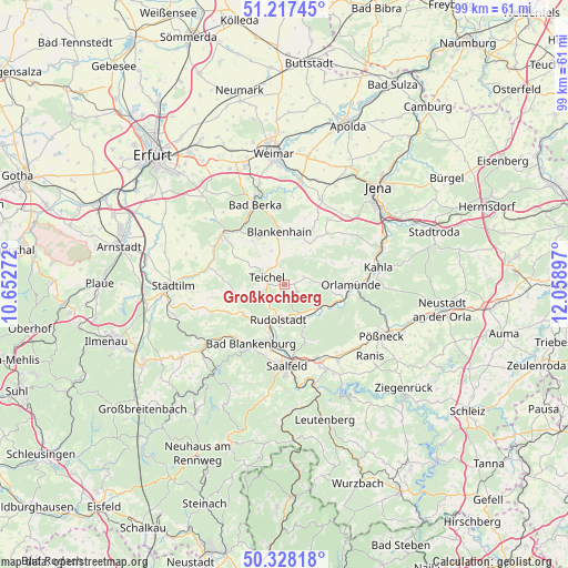
Großkochberg GPS coordinates[2]
50° 46' 29.748" North, 11° 21' 21.024" East
| Map corner | latitude | longitude |
|---|---|---|
| Upper-left | 51.21745°, | 10.65272° |
| Center: | 50.77493°, | 11.35584° |
| Lower-right: | 50.32818°, | 12.05897° |
| Map W x H: | 98.9×98.9 km | = 61.5×61.5mi |
| max Lat: | 55.01917° ⇑46.3% North |
| Großkochberg: | 50.77493° |
| min Lat: | ⇓53.7% South 47.40724° |
| min Long | Großkochberg | max Long |
| 5.92978° | 11.35584° | 14.98853° |
| W 72%⇐ | ⇒28% E |
Elevation
Elevation of Großkochberg is 351 m = 1152 ft, and this is 101.9 m = 334 ft above average elevation for this country.
| Max E: |
1256 m = 4121 ft | 31% |
| Großkochberg | 351 m 1152 ft | |
| Avg. | 249.1 m = 817 ft | |
Min E: |
-5 m = -16 ft | 69% |
See also: Germany elevation on elevation.city.
Geographical zone
Großkochberg is located in North temperate zone (between Tropic of Cancer and the Arctic Circle). Distance of this North polar circle is 1755.5 km =1090.8 mi to North.| Distance of | km | miles | from Großkochberg |
|---|---|---|---|
| North Pole | 4361.4 | 2710 | to North |
| Arctic Circle | 1755.5 | 1090.8 | to North |
| Tropic Cancer | 3039.7 | 1888.8 | to South |
| Equator | 5645.6 | 3508 | to South |


Nearby cities:
15 places around Großkochberg: (largest is in red/bold)
• Bad Blankenburg
11.9 km =7.4 mi,  209°
209°
• Bibra
13.8 km =8.6 mi,  76°
76°
• Blankenhain
9.5 km =5.9 mi,  354°
354°
• Eichenberg
12.8 km =8 mi, 77°
• Freienorla
13.7 km =8.5 mi,  93°
93°
• Gumperda
12.4 km =7.7 mi,  71°
71°
• Milda
11.8 km =7.3 mi,  40°
40°
• Naundorf
8.2 km =5.1 mi,  152°
152°
• Orlamünde
11.5 km =7.1 mi, 90°
• Reichenbach
11.5 km =7.1 mi, 150°
• Reinstädt
9.2 km =5.7 mi, 65°
• Rittersdorf
9.8 km =6.1 mi,  298°
298°
• Rudolstadt
6.2 km =3.9 mi,  190°
190°
• Rückersdorf
9.4 km =5.8 mi,  116°
116°
• Schwarza
9.1 km =5.7 mi, 345°
Sources, notices
• [Note1] Compared only with cities in Germany existing in our database
• [Src1] Map data: © OpenStreetMap contributors (CC-BY-SA)
• [Src2] Other city data from geonames.org with taken over terms of usage.
• [Src3] Geographical zone / Annual Mean Temperature by Robert A. Rohde @ Wikipedia
