Sachsenhagen geodata
Sachsenhagen (Lower Saxony) is a populated place; located in Germany in Europe/Berlin (GMT+2) time zone. With population of 2,154 people, there are 4863 cities with bigger population in this country. Compared to other cities in Germany, 76.1% of cities are located further ↓South; 61.2% of cities are located further →East and 79.2% of cities have higher elevation than Sachsenhagen. Note1
Administrative division(s):
- Level 1: Lower Saxony
- Level 3: Landkreis Schaumburg
- Level 4: Sachsenhagen


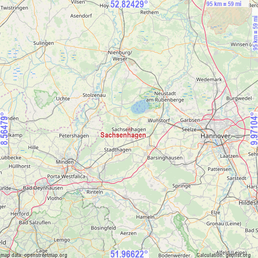
Sachsenhagen GPS coordinates[2]
52° 23' 50.424" North, 9° 16' 4.476" East
| Map corner | latitude | longitude |
|---|---|---|
| Upper-left | 52.82429°, | 8.56479° |
| Center: | 52.39734°, | 9.26791° |
| Lower-right: | 51.96622°, | 9.97104° |
| Map W x H: | 95.4×95.4 km | = 59.3×59.3mi |
| max Lat: | 55.01917° ⇑23.9% North |
| Sachsenhagen: | 52.39734° |
| min Lat: | ⇓76.1% South 47.40724° |
| min Long | Sachsenhagen | max Long |
| 5.92978° | 9.26791° | 14.98853° |
| W 38.8%⇐ | ⇒61.2% E |
Elevation
Elevation of Sachsenhagen is 49 m = 161 ft, and this is 200.1 m = 656 ft below average elevation for this country.
| Max E: |
1256 m = 4121 ft | 79.2% |
| Avg. | 249.1 m = 817 ft | |
| Sachsenhagen | 49 m = 161 ft | |
Min E: |
-5 m = -16 ft | 20.8% |
See also: Germany elevation on elevation.city.
Geographical zone
Sachsenhagen is located in North temperate zone (between Tropic of Cancer and the Arctic Circle). Distance of this North polar circle is 1575.1 km =978.7 mi to North.| Distance of | km | miles | from Sachsenhagen |
|---|---|---|---|
| North Pole | 4181 | 2598 | to North |
| Arctic Circle | 1575.1 | 978.7 | to North |
| Tropic Cancer | 3220.1 | 2000.9 | to South |
| Equator | 5826 | 3620.1 | to South |


Nearby cities:
15 places around Sachsenhagen: (largest is in red/bold)
• Auhagen
1.6 km =1 mi,  86°
86°
• Beckedorf
6.2 km =3.9 mi,  147°
147°
• Hagenburg
5.6 km =3.5 mi,  43°
43°
• Haste
8.7 km =5.4 mi,  102°
102°
• Heuerßen
7.6 km =4.7 mi,  175°
175°
• Hohnhorst
7.7 km =4.8 mi,  113°
113°
• Lauenhagen
6.3 km =3.9 mi,  221°
221°
• Lindhorst
4.5 km =2.8 mi,  166°
166°
• Lüdersfeld
4.3 km =2.7 mi,  192°
192°
• Niedernwöhren
9.6 km =6 mi,  238°
238°
• Nordsehl
7.8 km =4.8 mi,  227°
227°
• Pollhagen
5.6 km =3.5 mi,  256°
256°
• Rehburg-Loccum
9.3 km =5.8 mi,  330°
330°
• Stadthagen
9.3 km =5.8 mi,  208°
208°
• Wölpinghausen
3.2 km =2 mi,  312°
312°
Sources, notices
• [Note1] Compared only with cities in Germany existing in our database
• [Src1] Map data: © OpenStreetMap contributors (CC-BY-SA)
• [Src2] Other city data from geonames.org with taken over terms of usage.
• [Src3] Geographical zone / Annual Mean Temperature by Robert A. Rohde @ Wikipedia
