Auhagen geodata
Auhagen (Lower Saxony) is a seat of a fourth-order administrative division; located in Germany in Europe/Berlin (GMT+2) time zone. With population of 1,321 people, there are 6249 cities with bigger population in this country. Compared to other cities in Germany, 76.2% of cities are located further ↓South; 60.8% of cities are located further →East and 78.3% of cities have higher elevation than Auhagen. Note1


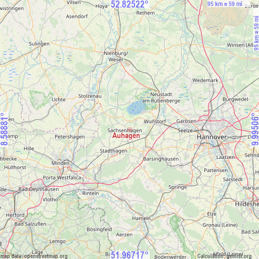
Auhagen GPS coordinates[2]
52° 23' 53.808" North, 9° 17' 30.984" East
| Map corner | latitude | longitude |
|---|---|---|
| Upper-left | 52.82522°, | 8.58881° |
| Center: | 52.39828°, | 9.29194° |
| Lower-right: | 51.96717°, | 9.99506° |
| Map W x H: | 95.4×95.4 km | = 59.3×59.3mi |
| max Lat: | 55.01917° ⇑23.8% North |
| Auhagen: | 52.39828° |
| min Lat: | ⇓76.2% South 47.40724° |
| min Long | Auhagen | max Long |
| 5.92978° | 9.29194° | 14.98853° |
| W 39.2%⇐ | ⇒60.8% E |
Elevation
Elevation of Auhagen is 52 m = 171 ft, and this is 197.1 m = 647 ft below average elevation for this country.
| Max E: |
1256 m = 4121 ft | 78.3% |
| Avg. | 249.1 m = 817 ft | |
| Auhagen | 52 m = 171 ft | |
Min E: |
-5 m = -16 ft | 21.7% |
See also: Germany elevation on elevation.city.
Geographical zone
Auhagen is located in North temperate zone (between Tropic of Cancer and the Arctic Circle). Distance of this North polar circle is 1575 km =978.7 mi to North.| Distance of | km | miles | from Auhagen |
|---|---|---|---|
| North Pole | 4180.9 | 2597.9 | to North |
| Arctic Circle | 1575 | 978.7 | to North |
| Tropic Cancer | 3220.2 | 2000.9 | to South |
| Equator | 5826.1 | 3620.2 | to South |


Nearby cities:
15 places around Auhagen: (largest is in red/bold)
• Bad Nenndorf
9 km =5.6 mi,  139°
139°
• Beckedorf
5.6 km =3.5 mi,  162°
162°
• Hagenburg
4.5 km =2.8 mi,  29°
29°
• Haste
7.1 km =4.4 mi,  105°
105°
• Heuerßen
7.7 km =4.8 mi,  187°
187°
• Hohnhorst
6.3 km =3.9 mi,  120°
120°
• Lauenhagen
7.5 km =4.7 mi,  230°
230°
• Lindhorst
4.5 km =2.8 mi, 187°
• Lüdersfeld
5 km =3.1 mi,  210°
210°
• Nordsehl
9.1 km =5.7 mi, 233°
• Pollhagen
7.2 km =4.5 mi,  258°
258°
• Rehburg-Loccum
10.1 km =6.3 mi,  321°
321°
• Sachsenhagen
1.6 km =1 mi,  266°
266°
• Wunstorf
10.2 km =6.3 mi,  73°
73°
• Wölpinghausen
4.5 km =2.8 mi,  297°
297°
Sources, notices
• [Note1] Compared only with cities in Germany existing in our database
• [Src1] Map data: © OpenStreetMap contributors (CC-BY-SA)
• [Src2] Other city data from geonames.org with taken over terms of usage.
• [Src3] Geographical zone / Annual Mean Temperature by Robert A. Rohde @ Wikipedia
