Hagenburg geodata
Hagenburg (Lower Saxony) is a populated place; located in Germany in Europe/Berlin (GMT+2) time zone. With population of 4,569 people, there are 2999 cities with bigger population in this country. Compared to other cities in Germany, 76.7% of cities are located further ↓South; 60.4% of cities are located further →East and 82% of cities have higher elevation than Hagenburg. Note1
Administrative division(s):
- Level 1: Lower Saxony
- Level 3: Landkreis Schaumburg
- Level 4: Hagenburg, Flecken


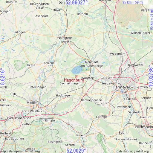
Hagenburg GPS coordinates[2]
52° 26' 1.212" North, 9° 19' 29.028" East
| Map corner | latitude | longitude |
|---|---|---|
| Upper-left | 52.86027°, | 8.6216° |
| Center: | 52.43367°, | 9.32473° |
| Lower-right: | 52.0029°, | 10.02786° |
| Map W x H: | 95.3×95.3 km | = 59.2×59.2mi |
| max Lat: | 55.01917° ⇑23.3% North |
| Hagenburg: | 52.43367° |
| min Lat: | ⇓76.7% South 47.40724° |
| min Long | Hagenburg | max Long |
| 5.92978° | 9.32473° | 14.98853° |
| W 39.6%⇐ | ⇒60.4% E |
Elevation
Elevation of Hagenburg is 42 m = 138 ft, and this is 207.1 m = 679 ft below average elevation for this country.
| Max E: |
1256 m = 4121 ft | 82% |
| Avg. | 249.1 m = 817 ft | |
| Hagenburg | 42 m = 138 ft | |
Min E: |
-5 m = -16 ft | 18% |
See also: Germany elevation on elevation.city.
Geographical zone
Hagenburg is located in North temperate zone (between Tropic of Cancer and the Arctic Circle). Distance of this North polar circle is 1571.1 km =976.2 mi to North.| Distance of | km | miles | from Hagenburg |
|---|---|---|---|
| North Pole | 4177 | 2595.5 | to North |
| Arctic Circle | 1571.1 | 976.2 | to North |
| Tropic Cancer | 3224.2 | 2003.4 | to South |
| Equator | 5830.1 | 3622.7 | to South |


Nearby cities:
15 places around Hagenburg: (largest is in red/bold)
• Auhagen
4.5 km =2.8 mi,  209°
209°
• Bad Nenndorf
11.4 km =7.1 mi,  161°
161°
• Beckedorf
9.3 km =5.8 mi,  183°
183°
• Haste
7.5 km =4.7 mi,  141°
141°
• Heuerßen
12 km =7.5 mi,  195°
195°
• Hohnhorst
7.8 km =4.8 mi, 155°
• Lauenhagen
11.8 km =7.3 mi,  222°
222°
• Lindhorst
8.9 km =5.5 mi, 198°
• Lüdersfeld
9.5 km =5.9 mi, 210°
• Neustadt am Rübenberge
12 km =7.5 mi,  49°
49°
• Pollhagen
10.7 km =6.6 mi,  239°
239°
• Rehburg-Loccum
9.4 km =5.8 mi,  295°
295°
• Sachsenhagen
5.6 km =3.5 mi, 223°
• Wunstorf
7.6 km =4.7 mi,  98°
98°
• Wölpinghausen
6.5 km =4 mi,  253°
253°
Sources, notices
• [Note1] Compared only with cities in Germany existing in our database
• [Src1] Map data: © OpenStreetMap contributors (CC-BY-SA)
• [Src2] Other city data from geonames.org with taken over terms of usage.
• [Src3] Geographical zone / Annual Mean Temperature by Robert A. Rohde @ Wikipedia
