Recklinghausen geodata
Recklinghausen (North Rhine-Westphalia) is a seat of a third-order administrative division; located in Germany in Europe/Berlin (GMT+2) time zone. With population of 122,438 people, there are 70 cities with bigger population in this country. Compared to other cities in Germany, 67.8% of cities are located further ↓South; 91.4% of cities are located further →East and 71.7% of cities have higher elevation than Recklinghausen. Note1
Administrative division(s):
- Level 1: North Rhine-Westphalia
- Level 2: Regierungsbezirk Münster
- Level 3: Kreis Recklinghausen
- Level 4: Recklinghausen


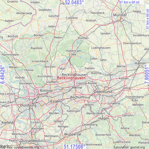
Recklinghausen GPS coordinates[2]
51° 36' 49.644" North, 7° 11' 50.568" East
| Map corner | latitude | longitude |
|---|---|---|
| Upper-left | 52.0483°, | 6.49426° |
| Center: | 51.61379°, | 7.19738° |
| Lower-right: | 51.17508°, | 7.90051° |
| Map W x H: | 97.1×97.1 km | = 60.3×60.3mi |
| max Lat: | 55.01917° ⇑32.2% North |
| Recklinghausen: | 51.61379° |
| min Lat: | ⇓67.8% South 47.40724° |
| min Long | Recklinghausen | max Long |
| 5.92978° | 7.19738° | 14.98853° |
| W 8.6%⇐ | ⇒91.4% E |
Elevation
Elevation of Recklinghausen is 80 m = 262 ft, and this is 169.1 m = 555 ft below average elevation for this country.
| Max E: |
1256 m = 4121 ft | 71.7% |
| Avg. | 249.1 m = 817 ft | |
| Recklinghausen | 80 m = 262 ft | |
Min E: |
-5 m = -16 ft | 28.3% |
See also: Recklinghausen elevation on elevation.city.
Geographical zone
Recklinghausen is located in North temperate zone (between Tropic of Cancer and the Arctic Circle). Distance of this North polar circle is 1662.3 km =1032.9 mi to North.| Distance of | km | miles | from Recklinghausen |
|---|---|---|---|
| North Pole | 4268.1 | 2652.1 | to North |
| Arctic Circle | 1662.3 | 1032.9 | to North |
| Tropic Cancer | 3133 | 1946.8 | to South |
| Equator | 5738.9 | 3566 | to South |


Nearby cities:
15 places around Recklinghausen: (largest is in red/bold)
• Bochum
14.8 km =9.2 mi,  174°
174°
• Bochum-Hordel
12.6 km =7.8 mi,  186°
186°
• Castrop-Rauxel
10.1 km =6.3 mi,  128°
128°
• Datteln
11.2 km =7 mi,  65°
65°
• Dorsten
16.9 km =10.5 mi,  288°
288°
• Gelsenkirchen
14 km =8.7 mi,  209°
209°
• Gladbeck
15.4 km =9.6 mi,  251°
251°
• Haltern am See
14.4 km =8.9 mi,  355°
355°
• Herne
8.6 km =5.3 mi, 166°
• Herten
4.2 km =2.6 mi,  242°
242°
• Hordel
13 km =8.1 mi, 186°
• Marl
8.8 km =5.5 mi,  302°
302°
• Oer-Erkenschwick
5.6 km =3.5 mi,  55°
55°
• Olfen
16.3 km =10.1 mi,  50°
50°
• Waltrop
14.2 km =8.8 mi,  86°
86°
Sources, notices
• [Note1] Compared only with cities in Germany existing in our database
• [Src1] Map data: © OpenStreetMap contributors (CC-BY-SA)
• [Src2] Other city data from geonames.org with taken over terms of usage.
• [Src3] Geographical zone / Annual Mean Temperature by Robert A. Rohde @ Wikipedia
