Gelsenkirchen geodata
Gelsenkirchen (North Rhine-Westphalia) is a seat of a third-order administrative division; located in Germany in Europe/Berlin (GMT+2) time zone. With population of 270,028 people, there are 27 cities with bigger population in this country. Compared to other cities in Germany, 66.4% of cities are located further ↓South; 92.4% of cities are located further →East and 79.4% of cities have higher elevation than Gelsenkirchen. Note1
Administrative division(s):
- Level 1: North Rhine-Westphalia
- Level 2: Regierungsbezirk Münster
- Level 3: Kreisfreie Stadt Gelsenkirchen
- Level 4: Gelsenkirchen


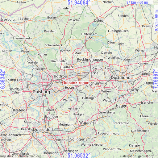
Gelsenkirchen GPS coordinates[2]
51° 30' 18.288" North, 7° 5' 47.544" East
| Map corner | latitude | longitude |
|---|---|---|
| Upper-left | 51.94064°, | 6.39342° |
| Center: | 51.50508°, | 7.09654° |
| Lower-right: | 51.06532°, | 7.79967° |
| Map W x H: | 97.3×97.3 km | = 60.5×60.5mi |
| max Lat: | 55.01917° ⇑33.6% North |
| Gelsenkirchen: | 51.50508° |
| min Lat: | ⇓66.4% South 47.40724° |
| min Long | Gelsenkirchen | max Long |
| 5.92978° | 7.09654° | 14.98853° |
| W 7.6%⇐ | ⇒92.4% E |
Elevation
Elevation of Gelsenkirchen is 48 m = 157 ft, and this is 201.1 m = 660 ft below average elevation for this country.
| Max E: |
1256 m = 4121 ft | 79.4% |
| Avg. | 249.1 m = 817 ft | |
| Gelsenkirchen | 48 m = 157 ft | |
Min E: |
-5 m = -16 ft | 20.6% |
See also: Gelsenkirchen elevation on elevation.city.
Geographical zone
Gelsenkirchen is located in North temperate zone (between Tropic of Cancer and the Arctic Circle). Distance of this North polar circle is 1674.3 km =1040.4 mi to North.| Distance of | km | miles | from Gelsenkirchen |
|---|---|---|---|
| North Pole | 4280.2 | 2659.6 | to North |
| Arctic Circle | 1674.3 | 1040.4 | to North |
| Tropic Cancer | 3120.9 | 1939.2 | to South |
| Equator | 5726.8 | 3558.5 | to South |


Nearby cities:
15 places around Gelsenkirchen: (largest is in red/bold)
• Bochum
8.7 km =5.4 mi,  107°
107°
• Bochum-Hordel
5.5 km =3.4 mi,  93°
93°
• Bottrop
11.8 km =7.3 mi,  280°
280°
• Castrop-Rauxel
15.9 km =9.9 mi,  68°
68°
• Essen
7.9 km =4.9 mi,  227°
227°
• Gladbeck
10.6 km =6.6 mi,  313°
313°
• Hattingen
13.3 km =8.3 mi,  152°
152°
• Herne
9.7 km =6 mi, 67°
• Herten
10.7 km =6.6 mi,  17°
17°
• Hordel
5.6 km =3.5 mi,  98°
98°
• Marl
16.9 km =10.5 mi,  358°
358°
• Mülheim
17.1 km =10.6 mi,  241°
241°
• Oberhausen
16.5 km =10.3 mi,  259°
259°
• Recklinghausen
14 km =8.7 mi,  29°
29°
• Witten
19 km =11.8 mi, 111°
Sources, notices
• [Note1] Compared only with cities in Germany existing in our database
• [Src1] Map data: © OpenStreetMap contributors (CC-BY-SA)
• [Src2] Other city data from geonames.org with taken over terms of usage.
• [Src3] Geographical zone / Annual Mean Temperature by Robert A. Rohde @ Wikipedia
