Hettenleidelheim geodata
Hettenleidelheim (Rheinland-Pfalz) is a seat of a fourth-order administrative division; located in Germany in Europe/Berlin (GMT+2) time zone. With population of 3,049 people, there are 3960 cities with bigger population in this country. Compared to other cities in Germany, 75.1% of cities are located further ↑North; 75.9% of cities are located further →East and 53.9% of cities have lower elevation than Hettenleidelheim. Note1
Administrative division(s):
- Level 1: Rheinland-Pfalz
- Level 3: Landkreis Bad Dürkheim
- Level 4: Hettenleidelheim


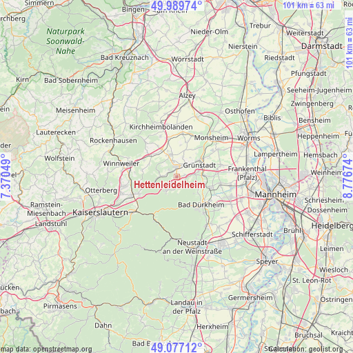
Hettenleidelheim GPS coordinates[2]
49° 32' 8.016" North, 8° 4' 24.996" East
| Map corner | latitude | longitude |
|---|---|---|
| Upper-left | 49.98974°, | 7.37049° |
| Center: | 49.53556°, | 8.07361° |
| Lower-right: | 49.07712°, | 8.77674° |
| Map W x H: | 101.5×101.5 km | = 63.1×63.1mi |
| max Lat: | 55.01917° ⇑75.1% North |
| Hettenleidelheim: | 49.53556° |
| min Lat: | ⇓24.9% South 47.40724° |
| min Long | Hettenleidelhei | max Long |
| 5.92978° | 8.07361° | 14.98853° |
| W 24.1%⇐ | ⇒75.9% E |
Elevation
Elevation of Hettenleidelheim is 251 m = 823 ft, and this is 1.9 m = 6 ft above average elevation for this country.
| Max E: |
1256 m = 4121 ft | 46.1% |
| Hettenleidelheim | 251 m 823 ft | |
| Avg. | 249.1 m = 817 ft | |
Min E: |
-5 m = -16 ft | 53.9% |
See also: Germany elevation on elevation.city.
Geographical zone
Hettenleidelheim is located in North temperate zone (between Tropic of Cancer and the Arctic Circle). Distance of this North polar circle is 1893.3 km =1176.4 mi to North.| Distance of | km | miles | from Hettenleidelheim |
|---|---|---|---|
| North Pole | 4499.2 | 2795.7 | to North |
| Arctic Circle | 1893.3 | 1176.4 | to North |
| Tropic Cancer | 2901.9 | 1803.2 | to South |
| Equator | 5507.8 | 3422.4 | to South |


Nearby cities:
15 places around Hettenleidelheim: (largest is in red/bold)
• Altleiningen
3.1 km =1.9 mi,  180°
180°
• Bobenheim am Berg
5.7 km =3.5 mi,  102°
102°
• Carlsberg
4.2 km =2.6 mi,  213°
213°
• Ebertsheim
4.4 km =2.7 mi,  34°
34°
• Eisenberg
2.6 km =1.6 mi,  357°
357°
• Kerzenheim
4.6 km =2.9 mi,  347°
347°
• Kleinkarlbach
5.5 km =3.4 mi,  86°
86°
• Lautersheim
6 km =3.7 mi,  17°
17°
• Mertesheim
6 km =3.7 mi,  48°
48°
• Neuleiningen
4.8 km =3 mi,  81°
81°
• Ramsen
4.4 km =2.7 mi,  272°
272°
• Rodenbach
4.9 km =3 mi, 29°
• Tiefenthal
2.2 km =1.4 mi, 81°
• Wattenheim
1.8 km =1.1 mi, 209°
• Weisenheim am Berg
6.3 km =3.9 mi,  113°
113°
Sources, notices
• [Note1] Compared only with cities in Germany existing in our database
• [Src1] Map data: © OpenStreetMap contributors (CC-BY-SA)
• [Src2] Other city data from geonames.org with taken over terms of usage.
• [Src3] Geographical zone / Annual Mean Temperature by Robert A. Rohde @ Wikipedia
