Philippsburg geodata
Philippsburg (Baden-Württemberg) is a populated place; located in Germany in Europe/Berlin (GMT+2) time zone. With population of 12,359 people, there are 1320 cities with bigger population in this country. Compared to other cities in Germany, 79.9% of cities are located further ↑North; 71.4% of cities are located further →East and 68.5% of cities have higher elevation than Philippsburg. Note1
Administrative division(s):
- Level 1: Baden-Württemberg
- Level 2: Karlsruhe Region
- Level 3: Landkreis Karlsruhe
- Level 4: Philippsburg


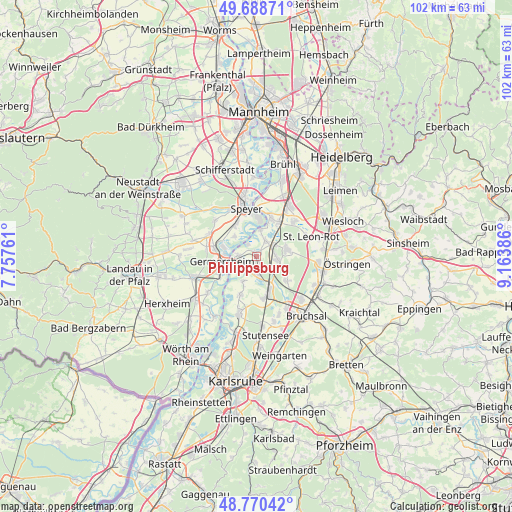
Philippsburg GPS coordinates[2]
49° 13' 54.12" North, 8° 27' 38.664" East
| Map corner | latitude | longitude |
|---|---|---|
| Upper-left | 49.68871°, | 7.75761° |
| Center: | 49.2317°, | 8.46074° |
| Lower-right: | 48.77042°, | 9.16386° |
| Map W x H: | 102.1×102.1 km | = 63.4×63.4mi |
| max Lat: | 55.01917° ⇑79.9% North |
| Philippsburg: | 49.2317° |
| min Lat: | ⇓20.1% South 47.40724° |
| min Long | Philippsburg | max Long |
| 5.92978° | 8.46074° | 14.98853° |
| W 28.6%⇐ | ⇒71.4% E |
Elevation
Elevation of Philippsburg is 100 m = 328 ft, and this is 149.1 m = 489 ft below average elevation for this country.
| Max E: |
1256 m = 4121 ft | 68.5% |
| Avg. | 249.1 m = 817 ft | |
| Philippsburg | 100 m = 328 ft | |
Min E: |
-5 m = -16 ft | 31.5% |
See also: Germany elevation on elevation.city.
Geographical zone
Philippsburg is located in North temperate zone (between Tropic of Cancer and the Arctic Circle). Distance of this North polar circle is 1927.1 km =1197.4 mi to North.| Distance of | km | miles | from Philippsburg |
|---|---|---|---|
| North Pole | 4533 | 2816.7 | to North |
| Arctic Circle | 1927.1 | 1197.4 | to North |
| Tropic Cancer | 2868.1 | 1782.2 | to South |
| Equator | 5474.1 | 3401.4 | to South |


Nearby cities:
15 places around Philippsburg: (largest is in red/bold)
• Altlußheim
8.3 km =5.2 mi,  19°
19°
• Dudenhofen
11 km =6.8 mi,  331°
331°
• Germersheim
7.1 km =4.4 mi,  262°
262°
• Graben-Neudorf
7.6 km =4.7 mi,  162°
162°
• Hambrücken
7.4 km =4.6 mi,  128°
128°
• Harthausen
10.9 km =6.8 mi,  309°
309°
• Lingenfeld
9.2 km =5.7 mi,  285°
285°
• Linkenheim-Hochstetten
11.6 km =7.2 mi,  197°
197°
• Neulußheim
8.5 km =5.3 mi,  29°
29°
• Oberhausen-Rheinhausen
4.8 km =3 mi,  9°
9°
• Reilingen
10.5 km =6.5 mi,  45°
45°
• Schwegenheim
10.5 km =6.5 mi, 293°
• Speyer
10.1 km =6.3 mi,  347°
347°
• Waghäusel
4.3 km =2.7 mi,  61°
61°
• Westheim
10.1 km =6.3 mi,  279°
279°
Sources, notices
• [Note1] Compared only with cities in Germany existing in our database
• [Src1] Map data: © OpenStreetMap contributors (CC-BY-SA)
• [Src2] Other city data from geonames.org with taken over terms of usage.
• [Src3] Geographical zone / Annual Mean Temperature by Robert A. Rohde @ Wikipedia
