Altlußheim geodata
Altlußheim (Baden-Württemberg) is a seat of a fourth-order administrative division; located in Germany in Europe/Berlin (GMT+2) time zone. With population of 5,289 people, there are 2703 cities with bigger population in this country. Compared to other cities in Germany, 78.6% of cities are located further ↑North; 71.1% of cities are located further →East and 68% of cities have higher elevation than Altlußheim. Note1
Administrative division(s):
- Level 1: Baden-Württemberg
- Level 2: Karlsruhe Region
- Level 3: Rhein-Neckar-Kreis
- Level 4: Altlußheim


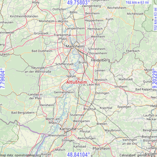
Altlußheim GPS coordinates[2]
49° 18' 6.012" North, 8° 29' 57.012" East
| Map corner | latitude | longitude |
|---|---|---|
| Upper-left | 49.75803°, | 7.79604° |
| Center: | 49.30167°, | 8.49917° |
| Lower-right: | 48.84104°, | 9.20229° |
| Map W x H: | 102×102 km | = 63.4×63.4mi |
| max Lat: | 55.01917° ⇑78.6% North |
| Altlußheim: | 49.30167° |
| min Lat: | ⇓21.4% South 47.40724° |
| min Long | Altlußheim | max Long |
| 5.92978° | 8.49917° | 14.98853° |
| W 28.9%⇐ | ⇒71.1% E |
Elevation
Elevation of Altlußheim is 102 m = 335 ft, and this is 147.1 m = 483 ft below average elevation for this country.
| Max E: |
1256 m = 4121 ft | 68% |
| Avg. | 249.1 m = 817 ft | |
| Altlußheim | 102 m = 335 ft | |
Min E: |
-5 m = -16 ft | 32% |
See also: Germany elevation on elevation.city.
Geographical zone
Altlußheim is located in North temperate zone (between Tropic of Cancer and the Arctic Circle). Distance of this North polar circle is 1919.3 km =1192.6 mi to North.| Distance of | km | miles | from Altlußheim |
|---|---|---|---|
| North Pole | 4525.2 | 2811.8 | to North |
| Arctic Circle | 1919.3 | 1192.6 | to North |
| Tropic Cancer | 2875.9 | 1787 | to South |
| Equator | 5481.8 | 3406.2 | to South |


Nearby cities:
15 places around Altlußheim: (largest is in red/bold)
• Brühl
10.9 km =6.8 mi,  13°
13°
• Dudenhofen
8.2 km =5.1 mi,  283°
283°
• Hockenheim
4.5 km =2.8 mi,  57°
57°
• Ketsch
7.7 km =4.8 mi,  17°
17°
• Neulußheim
1.4 km =0.9 mi,  106°
106°
• Oberhausen-Rheinhausen
3.7 km =2.3 mi,  212°
212°
• Oftersheim
9.3 km =5.8 mi,  40°
40°
• Otterstadt
8.7 km =5.4 mi,  334°
334°
• Philippsburg
8.3 km =5.2 mi,  199°
199°
• Reilingen
4.7 km =2.9 mi,  94°
94°
• Sankt Leon-Rot
9.5 km =5.9 mi, 114°
• Schwetzingen
10.8 km =6.7 mi,  33°
33°
• Speyer
5.4 km =3.4 mi,  293°
293°
• Waghäusel
5.8 km =3.6 mi,  170°
170°
• Walldorf
10.4 km =6.5 mi, 87°
Sources, notices
• [Note1] Compared only with cities in Germany existing in our database
• [Src1] Map data: © OpenStreetMap contributors (CC-BY-SA)
• [Src2] Other city data from geonames.org with taken over terms of usage.
• [Src3] Geographical zone / Annual Mean Temperature by Robert A. Rohde @ Wikipedia
