Oberhausen-Rheinhausen geodata
Oberhausen-Rheinhausen (Baden-Württemberg) is a seat of a fourth-order administrative division; located in Germany in Europe/Berlin (GMT+2) time zone. With population of 9,420 people, there are 1715 cities with bigger population in this country. Compared to other cities in Germany, 79.1% of cities are located further ↑North; 71.3% of cities are located further →East and 69.2% of cities have higher elevation than Oberhausen-Rheinhausen. Note1
Administrative division(s):
- Level 1: Baden-Württemberg
- Level 2: Karlsruhe Region
- Level 3: Landkreis Karlsruhe
- Level 4: Oberhausen-Rheinhausen


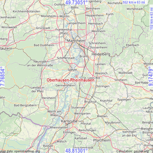
Oberhausen-Rheinhausen GPS coordinates[2]
49° 16' 26.004" North, 8° 28' 18.012" East
| Map corner | latitude | longitude |
|---|---|---|
| Upper-left | 49.73051°, | 7.76854° |
| Center: | 49.27389°, | 8.47167° |
| Lower-right: | 48.81301°, | 9.17479° |
| Map W x H: | 102×102 km | = 63.4×63.4mi |
| max Lat: | 55.01917° ⇑79.1% North |
| Oberhausen-Rheinhausen: | 49.27389° |
| min Lat: | ⇓20.9% South 47.40724° |
| min Long | Oberhausen-Rhei | max Long |
| 5.92978° | 8.47167° | 14.98853° |
| W 28.7%⇐ | ⇒71.3% E |
Elevation
Elevation of Oberhausen-Rheinhausen is 96 m = 315 ft, and this is 153.1 m = 502 ft below average elevation for this country.
| Max E: |
1256 m = 4121 ft | 69.2% |
| Avg. | 249.1 m = 817 ft | |
| Oberhausen-Rheinhausen | 96 m = 315 ft | |
Min E: |
-5 m = -16 ft | 30.8% |
See also: Germany elevation on elevation.city.
Geographical zone
Oberhausen-Rheinhausen is located in North temperate zone (between Tropic of Cancer and the Arctic Circle). Distance of this North polar circle is 1922.4 km =1194.5 mi to North.| Distance of | km | miles | from Oberhausen-Rheinhausen |
|---|---|---|---|
| North Pole | 4528.3 | 2813.8 | to North |
| Arctic Circle | 1922.4 | 1194.5 | to North |
| Tropic Cancer | 2872.8 | 1785.1 | to South |
| Equator | 5478.7 | 3404.3 | to South |


Nearby cities:
15 places around Oberhausen-Rheinhausen: (largest is in red/bold)
• Altlußheim
3.7 km =2.3 mi,  32°
32°
• Dudenhofen
7.8 km =4.8 mi,  309°
309°
• Germersheim
9.7 km =6 mi,  234°
234°
• Hambrücken
10.6 km =6.6 mi,  151°
151°
• Hanhofen
10.6 km =6.6 mi,  296°
296°
• Harthausen
9.5 km =5.9 mi,  283°
283°
• Hockenheim
8 km =5 mi,  46°
46°
• Lingenfeld
9.9 km =6.2 mi,  257°
257°
• Neulußheim
4.3 km =2.7 mi, 51°
• Philippsburg
4.8 km =3 mi,  189°
189°
• Reilingen
7.2 km =4.5 mi,  67°
67°
• Sankt Leon-Rot
10.7 km =6.6 mi,  94°
94°
• Schwegenheim
10.4 km =6.5 mi,  267°
267°
• Speyer
6 km =3.7 mi,  330°
330°
• Waghäusel
4 km =2.5 mi,  131°
131°
Sources, notices
• [Note1] Compared only with cities in Germany existing in our database
• [Src1] Map data: © OpenStreetMap contributors (CC-BY-SA)
• [Src2] Other city data from geonames.org with taken over terms of usage.
• [Src3] Geographical zone / Annual Mean Temperature by Robert A. Rohde @ Wikipedia
