Waghäusel geodata
Waghäusel (Baden-Württemberg) is a populated place; located in Germany in Europe/Berlin (GMT+2) time zone. With population of 20,178 people, there are 768 cities with bigger population in this country. Compared to other cities in Germany, 79.5% of cities are located further ↑North; 71% of cities are located further →East and 67.3% of cities have higher elevation than Waghäusel. Note1
Administrative division(s):
- Level 1: Baden-Württemberg
- Level 2: Karlsruhe Region
- Level 3: Landkreis Karlsruhe
- Level 4: Waghäusel


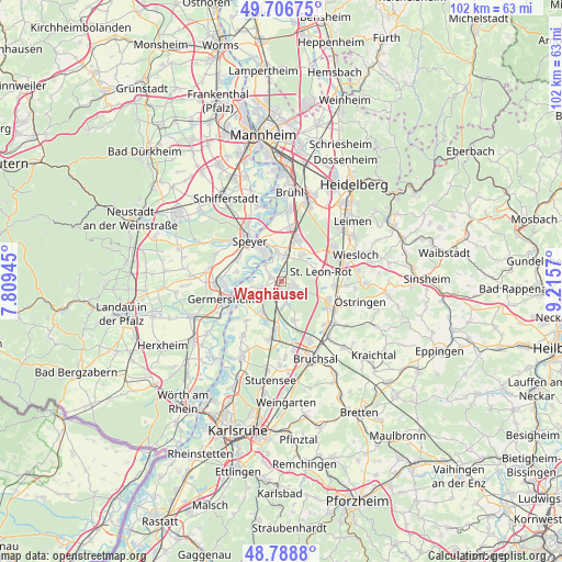
Waghäusel GPS coordinates[2]
49° 14' 59.676" North, 8° 30' 45.252" East
| Map corner | latitude | longitude |
|---|---|---|
| Upper-left | 49.70675°, | 7.80945° |
| Center: | 49.24991°, | 8.51257° |
| Lower-right: | 48.7888°, | 9.2157° |
| Map W x H: | 102.1×102.1 km | = 63.4×63.4mi |
| max Lat: | 55.01917° ⇑79.5% North |
| Waghäusel: | 49.24991° |
| min Lat: | ⇓20.5% South 47.40724° |
| min Long | Waghäusel | max Long |
| 5.92978° | 8.51257° | 14.98853° |
| W 29%⇐ | ⇒71% E |
Elevation
Elevation of Waghäusel is 106 m = 348 ft, and this is 143.1 m = 469 ft below average elevation for this country.
| Max E: |
1256 m = 4121 ft | 67.3% |
| Avg. | 249.1 m = 817 ft | |
| Waghäusel | 106 m = 348 ft | |
Min E: |
-5 m = -16 ft | 32.7% |
See also: Germany elevation on elevation.city.
Geographical zone
Waghäusel is located in North temperate zone (between Tropic of Cancer and the Arctic Circle). Distance of this North polar circle is 1925.1 km =1196.2 mi to North.| Distance of | km | miles | from Waghäusel |
|---|---|---|---|
| North Pole | 4531 | 2815.4 | to North |
| Arctic Circle | 1925.1 | 1196.2 | to North |
| Tropic Cancer | 2870.2 | 1783.5 | to South |
| Equator | 5476.1 | 3402.7 | to South |


Nearby cities:
15 places around Waghäusel: (largest is in red/bold)
• Altlußheim
5.8 km =3.6 mi,  350°
350°
• Dudenhofen
11.8 km =7.3 mi,  310°
310°
• Forst
11.3 km =7 mi,  153°
153°
• Germersheim
11.2 km =7 mi,  254°
254°
• Graben-Neudorf
9.3 km =5.8 mi,  189°
189°
• Hambrücken
7 km =4.3 mi,  163°
163°
• Hockenheim
8.6 km =5.3 mi,  19°
19°
• Kronau
9.1 km =5.7 mi,  109°
109°
• Neulußheim
5.4 km =3.4 mi,  4°
4°
• Oberhausen-Rheinhausen
4 km =2.5 mi, 311°
• Philippsburg
4.3 km =2.7 mi,  241°
241°
• Reilingen
6.6 km =4.1 mi,  34°
34°
• Sankt Leon-Rot
7.9 km =4.9 mi,  76°
76°
• Speyer
9.9 km =6.2 mi,  323°
323°
• Walldorf
11.3 km =7 mi,  56°
56°
Sources, notices
• [Note1] Compared only with cities in Germany existing in our database
• [Src1] Map data: © OpenStreetMap contributors (CC-BY-SA)
• [Src2] Other city data from geonames.org with taken over terms of usage.
• [Src3] Geographical zone / Annual Mean Temperature by Robert A. Rohde @ Wikipedia
