Speyer geodata
Speyer (Rheinland-Pfalz) is a seat of a third-order administrative division; located in Germany in Europe/Berlin (GMT+2) time zone. With population of 50,343 people, there are 224 cities with bigger population in this country. Compared to other cities in Germany, 78.3% of cities are located further ↑North; 71.7% of cities are located further →East and 66.5% of cities have higher elevation than Speyer. Note1
Administrative division(s):
- Level 1: Rheinland-Pfalz
- Level 3: Kreisfreie Stadt Speyer
- Level 4: Speyer


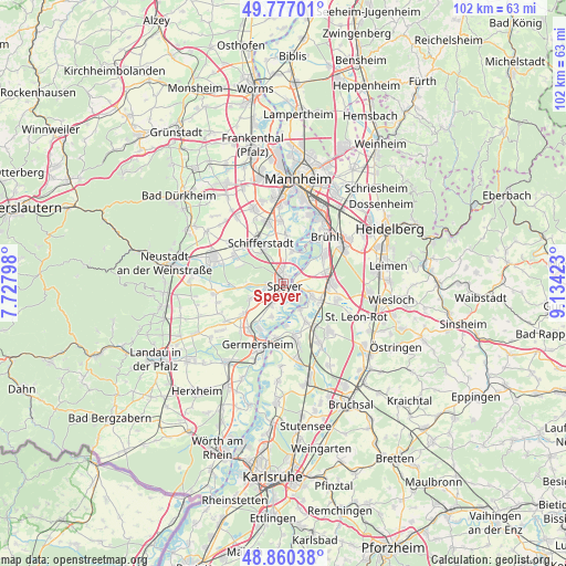
Speyer GPS coordinates[2]
49° 19' 14.988" North, 8° 25' 51.996" East
| Map corner | latitude | longitude |
|---|---|---|
| Upper-left | 49.77701°, | 7.72798° |
| Center: | 49.32083°, | 8.43111° |
| Lower-right: | 48.86038°, | 9.13423° |
| Map W x H: | 101.9×101.9 km | = 63.3×63.3mi |
| max Lat: | 55.01917° ⇑78.3% North |
| Speyer: | 49.32083° |
| min Lat: | ⇓21.7% South 47.40724° |
| min Long | Speyer | max Long |
| 5.92978° | 8.43111° | 14.98853° |
| W 28.3%⇐ | ⇒71.7% E |
Elevation
Elevation of Speyer is 111 m = 364 ft, and this is 138.1 m = 453 ft below average elevation for this country.
| Max E: |
1256 m = 4121 ft | 66.5% |
| Avg. | 249.1 m = 817 ft | |
| Speyer | 111 m = 364 ft | |
Min E: |
-5 m = -16 ft | 33.5% |
See also: Speyer elevation on elevation.city.
Geographical zone
Speyer is located in North temperate zone (between Tropic of Cancer and the Arctic Circle). Distance of this North polar circle is 1917.2 km =1191.3 mi to North.| Distance of | km | miles | from Speyer |
|---|---|---|---|
| North Pole | 4523.1 | 2810.5 | to North |
| Arctic Circle | 1917.2 | 1191.3 | to North |
| Tropic Cancer | 2878 | 1788.3 | to South |
| Equator | 5484 | 3407.6 | to South |


Nearby cities:
15 places around Speyer: (largest is in red/bold)
• Altlußheim
5.4 km =3.4 mi,  113°
113°
• Dudenhofen
3.1 km =1.9 mi,  265°
265°
• Hanhofen
6.6 km =4.1 mi, 265°
• Harthausen
6.9 km =4.3 mi,  244°
244°
• Hockenheim
8.8 km =5.5 mi,  88°
88°
• Ketsch
8.9 km =5.5 mi,  54°
54°
• Lingenfeld
10 km =6.2 mi,  222°
222°
• Neulußheim
6.8 km =4.2 mi, 111°
• Oberhausen-Rheinhausen
6 km =3.7 mi,  150°
150°
• Otterstadt
5.8 km =3.6 mi,  11°
11°
• Reilingen
10 km =6.2 mi,  104°
104°
• Schifferstadt
8 km =5 mi,  331°
331°
• Schwegenheim
9.3 km =5.8 mi,  232°
232°
• Waghäusel
9.9 km =6.2 mi,  143°
143°
• Waldsee
8.3 km =5.2 mi,  4°
4°
In other languages:
- In Spanish: Espira
- In France: Spire
- In Italian: Spira
- In Russian: Шпайер
- In Chinese: 施派尔
Sources, notices
• [Note1] Compared only with cities in Germany existing in our database
• [Src1] Map data: © OpenStreetMap contributors (CC-BY-SA)
• [Src2] Other city data from geonames.org with taken over terms of usage.
• [Src3] Geographical zone / Annual Mean Temperature by Robert A. Rohde @ Wikipedia
