Hettingen geodata
Hettingen (Baden-Württemberg) is a populated place; located in Germany in Europe/Berlin (GMT+2) time zone. With population of 2,059 people, there are 4986 cities with bigger population in this country. Compared to other cities in Germany, 92.5% of cities are located further ↑North; 61.8% of cities are located further →East and 96.6% of cities have lower elevation than Hettingen. Note1
Administrative division(s):
- Level 1: Baden-Württemberg
- Level 2: Tübingen Region
- Level 3: Landkreis Sigmaringen
- Level 4: Hettingen


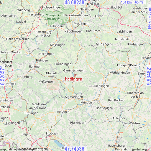
Hettingen GPS coordinates[2]
48° 12' 57.636" North, 9° 13' 54.084" East
| Map corner | latitude | longitude |
|---|---|---|
| Upper-left | 48.68238°, | 8.52857° |
| Center: | 48.21601°, | 9.23169° |
| Lower-right: | 47.74536°, | 9.93482° |
| Map W x H: | 104.2×104.2 km | = 64.7×64.7mi |
| max Lat: | 55.01917° ⇑92.5% North |
| Hettingen: | 48.21601° |
| min Lat: | ⇓7.5% South 47.40724° |
| min Long | Hettingen | max Long |
| 5.92978° | 9.23169° | 14.98853° |
| W 38.2%⇐ | ⇒61.8% E |
Elevation
Elevation of Hettingen is 649 m = 2129 ft, and this is 399.9 m = 1312 ft above average elevation for this country.
| Max E: |
1256 m = 4121 ft | 3.4% |
| Hettingen | 649 m 2129 ft | |
| Avg. | 249.1 m = 817 ft | |
Min E: |
-5 m = -16 ft | 96.6% |
See also: Germany elevation on elevation.city.
Geographical zone
Hettingen is located in North temperate zone (between Tropic of Cancer and the Arctic Circle). Distance of this North polar circle is 2040.1 km =1267.7 mi to North.| Distance of | km | miles | from Hettingen |
|---|---|---|---|
| North Pole | 4645.9 | 2886.8 | to North |
| Arctic Circle | 2040.1 | 1267.7 | to North |
| Tropic Cancer | 2755.2 | 1712 | to South |
| Equator | 5361.1 | 3331.2 | to South |


Nearby cities:
15 places around Hettingen: (largest is in red/bold)
• Albstadt
15.2 km =9.4 mi,  270°
270°
• Bingen
12 km =7.5 mi,  165°
165°
• Bitz
10.8 km =6.7 mi,  286°
286°
• Burladingen
12.1 km =7.5 mi,  313°
313°
• Gammertingen
4.1 km =2.5 mi,  351°
351°
• Langenenslingen
13.2 km =8.2 mi,  124°
124°
• Neufra
5 km =3.1 mi, 314°
• Pfronstetten
11.6 km =7.2 mi,  54°
54°
• Scheer
16.6 km =10.3 mi,  163°
163°
• Sigmaringen
14.2 km =8.8 mi,  180°
180°
• Stetten am Kalten Markt
15.3 km =9.5 mi,  228°
228°
• Straßberg
11.3 km =7 mi,  248°
248°
• Trochtelfingen
10.3 km =6.4 mi,  5°
5°
• Veringenstadt
3.8 km =2.4 mi,  204°
204°
• Winterlingen
9.3 km =5.8 mi, 246°
Sources, notices
• [Note1] Compared only with cities in Germany existing in our database
• [Src1] Map data: © OpenStreetMap contributors (CC-BY-SA)
• [Src2] Other city data from geonames.org with taken over terms of usage.
• [Src3] Geographical zone / Annual Mean Temperature by Robert A. Rohde @ Wikipedia
