Gammelsdorf geodata
Gammelsdorf (Bavaria) is a seat of a fourth-order administrative division; located in Germany in Europe/Berlin (GMT+2) time zone. With population of 1,471 people, there are 5937 cities with bigger population in this country. Compared to other cities in Germany, 88.5% of cities are located further ↑North; 81.1% of cities are located further ←West and 87.9% of cities have lower elevation than Gammelsdorf. Note1
Administrative division(s):
- Level 1: Bavaria
- Level 2: Upper Bavaria
- Level 3: Landkreis Freising
- Level 4: Gammelsdorf


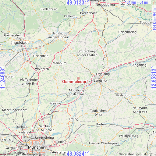
Gammelsdorf GPS coordinates[2]
48° 33' 0" North, 11° 57' 0" East
| Map corner | latitude | longitude |
|---|---|---|
| Upper-left | 49.01331°, | 11.24688° |
| Center: | 48.55°, | 11.95° |
| Lower-right: | 48.08241°, | 12.65313° |
| Map W x H: | 103.5×103.5 km | = 64.3×64.3mi |
| max Lat: | 55.01917° ⇑88.5% North |
| Gammelsdorf: | 48.55° |
| min Lat: | ⇓11.5% South 47.40724° |
| min Long | Gammelsdorf | max Long |
| 5.92978° | 11.95° | 14.98853° |
| W 81.1%⇐ | ⇒18.9% E |
Elevation
Elevation of Gammelsdorf is 493 m = 1617 ft, and this is 243.9 m = 800 ft above average elevation for this country.
| Max E: |
1256 m = 4121 ft | 12.1% |
| Gammelsdorf | 493 m 1617 ft | |
| Avg. | 249.1 m = 817 ft | |
Min E: |
-5 m = -16 ft | 87.9% |
See also: Germany elevation on elevation.city.
Geographical zone
Gammelsdorf is located in North temperate zone (between Tropic of Cancer and the Arctic Circle). Distance of this North polar circle is 2002.9 km =1244.5 mi to North.| Distance of | km | miles | from Gammelsdorf |
|---|---|---|---|
| North Pole | 4608.8 | 2863.8 | to North |
| Arctic Circle | 2002.9 | 1244.5 | to North |
| Tropic Cancer | 2792.3 | 1735.1 | to South |
| Equator | 5398.3 | 3354.3 | to South |


Nearby cities:
15 places around Gammelsdorf: (largest is in red/bold)
• Attenhofen
13.5 km =8.4 mi,  326°
326°
• Bruckberg
4.5 km =2.8 mi,  133°
133°
• Eching
10.2 km =6.3 mi,  122°
122°
• Furth
6.9 km =4.3 mi,  48°
48°
• Haag an der Amper
13.6 km =8.5 mi,  221°
221°
• Hörgertshausen
6.1 km =3.8 mi,  270°
270°
• Mauern
5.2 km =3.2 mi, 224°
• Moosburg
8.8 km =5.5 mi,  185°
185°
• Nandlstadt
10.6 km =6.6 mi,  261°
261°
• Obersüßbach
7.4 km =4.6 mi,  0°
0°
• Pfeffenhausen
12.8 km =8 mi,  5°
5°
• Tiefenbach
12.4 km =7.7 mi, 116°
• Volkenschwand
7.4 km =4.6 mi,  318°
318°
• Wang
6.1 km =3.8 mi, 189°
• Weihmichl
9.2 km =5.7 mi, 52°
Sources, notices
• [Note1] Compared only with cities in Germany existing in our database
• [Src1] Map data: © OpenStreetMap contributors (CC-BY-SA)
• [Src2] Other city data from geonames.org with taken over terms of usage.
• [Src3] Geographical zone / Annual Mean Temperature by Robert A. Rohde @ Wikipedia
