Schiltberg geodata
Schiltberg (Bavaria) is a seat of a fourth-order administrative division; located in Germany in Europe/Berlin (GMT+2) time zone. With population of 1,824 people, there are 5306 cities with bigger population in this country. Compared to other cities in Germany, 89.5% of cities are located further ↑North; 70.6% of cities are located further ←West and 83.1% of cities have lower elevation than Schiltberg. Note1
Administrative division(s):
- Level 1: Bavaria
- Level 2: Swabia
- Level 3: Landkreis Aichach-Friedberg
- Level 4: Schiltberg


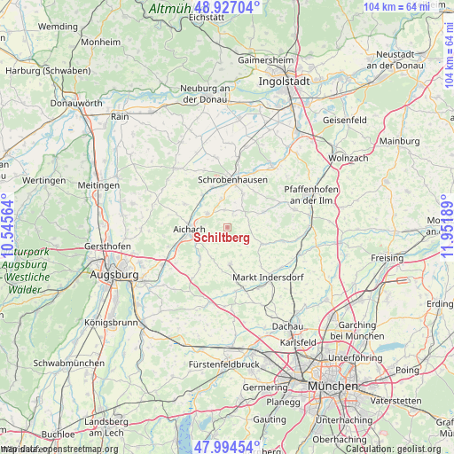
Schiltberg GPS coordinates[2]
48° 27' 46.548" North, 11° 14' 55.536" East
| Map corner | latitude | longitude |
|---|---|---|
| Upper-left | 48.92704°, | 10.54564° |
| Center: | 48.46293°, | 11.24876° |
| Lower-right: | 47.99454°, | 11.95189° |
| Map W x H: | 103.7×103.7 km | = 64.4×64.4mi |
| max Lat: | 55.01917° ⇑89.5% North |
| Schiltberg: | 48.46293° |
| min Lat: | ⇓10.5% South 47.40724° |
| min Long | Schiltberg | max Long |
| 5.92978° | 11.24876° | 14.98853° |
| W 70.6%⇐ | ⇒29.4% E |
Elevation
Elevation of Schiltberg is 454 m = 1490 ft, and this is 204.9 m = 672 ft above average elevation for this country.
| Max E: |
1256 m = 4121 ft | 16.9% |
| Schiltberg | 454 m 1490 ft | |
| Avg. | 249.1 m = 817 ft | |
Min E: |
-5 m = -16 ft | 83.1% |
See also: Germany elevation on elevation.city.
Geographical zone
Schiltberg is located in North temperate zone (between Tropic of Cancer and the Arctic Circle). Distance of this North polar circle is 2012.6 km =1250.6 mi to North.| Distance of | km | miles | from Schiltberg |
|---|---|---|---|
| North Pole | 4618.5 | 2869.8 | to North |
| Arctic Circle | 2012.6 | 1250.6 | to North |
| Tropic Cancer | 2782.7 | 1729.1 | to South |
| Equator | 5388.6 | 3348.3 | to South |


Nearby cities:
15 places around Schiltberg: (largest is in red/bold)
• Aichach
8.5 km =5.3 mi,  265°
265°
• Altomünster
8.4 km =5.2 mi,  175°
175°
• Aresing
8.7 km =5.4 mi,  25°
25°
• Gachenbach
4.3 km =2.7 mi,  344°
344°
• Gerolsbach
8.9 km =5.5 mi,  68°
68°
• Hilgertshausen-Tandern
8.6 km =5.3 mi,  115°
115°
• Hollenbach
13.6 km =8.5 mi,  279°
279°
• Inchenhofen
11.3 km =7 mi,  299°
299°
• Jetzendorf
12.8 km =8 mi,  104°
104°
• Kühbach
5.5 km =3.4 mi, 304°
• Pfaffenhofen
8.4 km =5.2 mi,  202°
202°
• Ried
1.8 km =1.1 mi, 29°
• Schrobenhausen
10.9 km =6.8 mi,  4°
4°
• Schwabhausen
10.5 km =6.5 mi,  130°
130°
• Sielenbach
9.3 km =5.8 mi,  220°
220°
Sources, notices
• [Note1] Compared only with cities in Germany existing in our database
• [Src1] Map data: © OpenStreetMap contributors (CC-BY-SA)
• [Src2] Other city data from geonames.org with taken over terms of usage.
• [Src3] Geographical zone / Annual Mean Temperature by Robert A. Rohde @ Wikipedia
