Ried geodata
Ried (Bavaria) is a populated place; located in Germany in Europe/Berlin (GMT+2) time zone. With population of 2,987 people, there are 4013 cities with bigger population in this country. Compared to other cities in Germany, 89.4% of cities are located further ↑North; 70.8% of cities are located further ←West and 82.6% of cities have lower elevation than Ried. Note1
Administrative division(s):
- Level 1: Bavaria
- Level 2: Upper Bavaria
- Level 3: Landkreis Neuburg-Schrobenhausen
- Level 4: Gachenbach


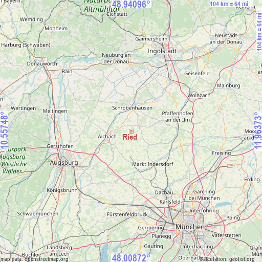
Ried GPS coordinates[2]
48° 28' 37.128" North, 11° 15' 38.16" East
| Map corner | latitude | longitude |
|---|---|---|
| Upper-left | 48.94096°, | 10.55748° |
| Center: | 48.47698°, | 11.2606° |
| Lower-right: | 48.00872°, | 11.96373° |
| Map W x H: | 103.7×103.7 km | = 64.4×64.4mi |
| max Lat: | 55.01917° ⇑89.4% North |
| Ried: | 48.47698° |
| min Lat: | ⇓10.6% South 47.40724° |
| min Long | Ried | max Long |
| 5.92978° | 11.2606° | 14.98853° |
| W 70.8%⇐ | ⇒29.2% E |
Elevation
Elevation of Ried is 450 m = 1476 ft, and this is 200.9 m = 659 ft above average elevation for this country.
| Max E: |
1256 m = 4121 ft | 17.4% |
| Ried | 450 m 1476 ft | |
| Avg. | 249.1 m = 817 ft | |
Min E: |
-5 m = -16 ft | 82.6% |
See also: Germany elevation on elevation.city.
Geographical zone
Ried is located in North temperate zone (between Tropic of Cancer and the Arctic Circle). Distance of this North polar circle is 2011 km =1249.6 mi to North.| Distance of | km | miles | from Ried |
|---|---|---|---|
| North Pole | 4616.9 | 2868.8 | to North |
| Arctic Circle | 2011 | 1249.6 | to North |
| Tropic Cancer | 2784.2 | 1730 | to South |
| Equator | 5390.1 | 3349.3 | to South |


Nearby cities:
15 places around Ried: (largest is in red/bold)
• Aichach
9.6 km =6 mi,  256°
256°
• Altomünster
9.9 km =6.2 mi,  181°
181°
• Aresing
6.9 km =4.3 mi,  24°
24°
• Gachenbach
3.3 km =2.1 mi,  321°
321°
• Gerolsbach
7.6 km =4.7 mi,  76°
76°
• Hilgertshausen-Tandern
8.7 km =5.4 mi,  127°
127°
• Inchenhofen
11.5 km =7.1 mi,  290°
290°
• Jetzendorf
12.5 km =7.8 mi,  112°
112°
• Kühbach
5.7 km =3.5 mi, 286°
• Pfaffenhofen
10.1 km =6.3 mi,  203°
203°
• Schiltberg
1.8 km =1.1 mi,  209°
209°
• Schrobenhausen
9.3 km =5.8 mi,  0°
0°
• Schwabhausen
11 km =6.8 mi,  139°
139°
• Sielenbach
11 km =6.8 mi,  218°
218°
• Waidhofen
12.4 km =7.7 mi,  26°
26°
Sources, notices
• [Note1] Compared only with cities in Germany existing in our database
• [Src1] Map data: © OpenStreetMap contributors (CC-BY-SA)
• [Src2] Other city data from geonames.org with taken over terms of usage.
• [Src3] Geographical zone / Annual Mean Temperature by Robert A. Rohde @ Wikipedia
