Kühbach geodata
Kühbach (Bavaria) is a populated place; located in Germany in Europe/Berlin (GMT+2) time zone. With population of 3,997 people, there are 3303 cities with bigger population in this country. Compared to other cities in Germany, 89.2% of cities are located further ↑North; 69.7% of cities are located further ←West and 83.4% of cities have lower elevation than Kühbach. Note1
Administrative division(s):
- Level 1: Bavaria
- Level 2: Swabia
- Level 3: Landkreis Aichach-Friedberg
- Level 4: Kühbach, Markt


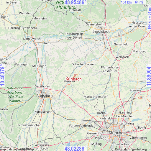
Kühbach GPS coordinates[2]
48° 29' 27.636" North, 11° 11' 12.876" East
| Map corner | latitude | longitude |
|---|---|---|
| Upper-left | 48.95486°, | 10.48379° |
| Center: | 48.49101°, | 11.18691° |
| Lower-right: | 48.02288°, | 11.89004° |
| Map W x H: | 103.6×103.6 km | = 64.4×64.4mi |
| max Lat: | 55.01917° ⇑89.2% North |
| Kühbach: | 48.49101° |
| min Lat: | ⇓10.8% South 47.40724° |
| min Long | Kühbach | max Long |
| 5.92978° | 11.18691° | 14.98853° |
| W 69.7%⇐ | ⇒30.3% E |
Elevation
Elevation of Kühbach is 457 m = 1499 ft, and this is 207.9 m = 682 ft above average elevation for this country.
| Max E: |
1256 m = 4121 ft | 16.6% |
| Kühbach | 457 m 1499 ft | |
| Avg. | 249.1 m = 817 ft | |
Min E: |
-5 m = -16 ft | 83.4% |
See also: Germany elevation on elevation.city.
Geographical zone
Kühbach is located in North temperate zone (between Tropic of Cancer and the Arctic Circle). Distance of this North polar circle is 2009.5 km =1248.6 mi to North.| Distance of | km | miles | from Kühbach |
|---|---|---|---|
| North Pole | 4615.4 | 2867.9 | to North |
| Arctic Circle | 2009.5 | 1248.6 | to North |
| Tropic Cancer | 2785.8 | 1731 | to South |
| Equator | 5391.7 | 3350.2 | to South |


Nearby cities:
15 places around Kühbach: (largest is in red/bold)
• Aichach
5.4 km =3.4 mi,  226°
226°
• Altomünster
12.6 km =7.8 mi,  155°
155°
• Aresing
9.6 km =6 mi,  60°
60°
• Gachenbach
3.6 km =2.2 mi,  73°
73°
• Gerolsbach
12.9 km =8 mi,  89°
89°
• Hollenbach
8.9 km =5.5 mi,  264°
264°
• Inchenhofen
5.9 km =3.7 mi,  294°
294°
• Obergriesbach
11.5 km =7.1 mi, 229°
• Petersdorf
11.7 km =7.3 mi,  284°
284°
• Pfaffenhofen
10.9 km =6.8 mi,  172°
172°
• Pöttmes
12.6 km =7.8 mi,  324°
324°
• Ried
5.7 km =3.5 mi,  106°
106°
• Schiltberg
5.5 km =3.4 mi,  124°
124°
• Schrobenhausen
9.5 km =5.9 mi,  35°
35°
• Sielenbach
10.2 km =6.3 mi,  188°
188°
Sources, notices
• [Note1] Compared only with cities in Germany existing in our database
• [Src1] Map data: © OpenStreetMap contributors (CC-BY-SA)
• [Src2] Other city data from geonames.org with taken over terms of usage.
• [Src3] Geographical zone / Annual Mean Temperature by Robert A. Rohde @ Wikipedia
