Petershagen geodata
Petershagen (North Rhine-Westphalia) is a populated place; located in Germany in Europe/Berlin (GMT+2) time zone. With population of 27,090 people, there are 530 cities with bigger population in this country. Compared to other cities in Germany, 75.9% of cities are located further ↓South; 65.9% of cities are located further →East and 80.2% of cities have higher elevation than Petershagen. Note1
Administrative division(s):
- Level 1: North Rhine-Westphalia
- Level 2: Regierungsbezirk Detmold
- Level 3: Kreis Minden-Lübbecke
- Level 4: Petershagen


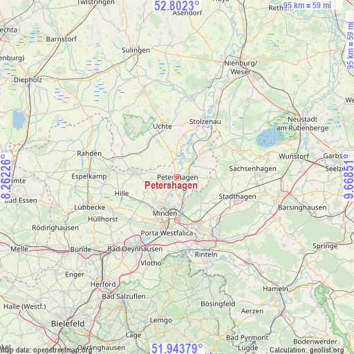
Petershagen GPS coordinates[2]
52° 22' 30.468" North, 8° 57' 55.368" East
| Map corner | latitude | longitude |
|---|---|---|
| Upper-left | 52.8023°, | 8.26226° |
| Center: | 52.37513°, | 8.96538° |
| Lower-right: | 51.94379°, | 9.66851° |
| Map W x H: | 95.5×95.5 km | = 59.3×59.3mi |
| max Lat: | 55.01917° ⇑24.1% North |
| Petershagen: | 52.37513° |
| min Lat: | ⇓75.9% South 47.40724° |
| min Long | Petershagen | max Long |
| 5.92978° | 8.96538° | 14.98853° |
| W 34.1%⇐ | ⇒65.9% E |
Elevation
Elevation of Petershagen is 46 m = 151 ft, and this is 203.1 m = 666 ft below average elevation for this country.
| Max E: |
1256 m = 4121 ft | 80.2% |
| Avg. | 249.1 m = 817 ft | |
| Petershagen | 46 m = 151 ft | |
Min E: |
-5 m = -16 ft | 19.8% |
See also: Germany elevation on elevation.city.
Geographical zone
Petershagen is located in North temperate zone (between Tropic of Cancer and the Arctic Circle). Distance of this North polar circle is 1577.6 km =980.3 mi to North.| Distance of | km | miles | from Petershagen |
|---|---|---|---|
| North Pole | 4183.5 | 2599.5 | to North |
| Arctic Circle | 1577.6 | 980.3 | to North |
| Tropic Cancer | 3217.6 | 1999.3 | to South |
| Equator | 5823.6 | 3618.6 | to South |


Nearby cities:
15 places around Petershagen: (largest is in red/bold)
• Bückeburg
14 km =8.7 mi,  155°
155°
• Halle
6 km =3.7 mi,  330°
330°
• Helpsen
12.5 km =7.8 mi,  124°
124°
• Hespe
10.9 km =6.8 mi, 117°
• Hille
15.3 km =9.5 mi,  252°
252°
• Meerbeck
13.1 km =8.1 mi,  106°
106°
• Minden
10.1 km =6.3 mi,  199°
199°
• Niedernwöhren
12.7 km =7.9 mi,  101°
101°
• Nordsehl
15.1 km =9.4 mi, 100°
• Pollhagen
15.2 km =9.4 mi,  85°
85°
• Raddestorf
8.3 km =5.2 mi,  0°
0°
• Seggebruch
12.1 km =7.5 mi,  133°
133°
• Uchte
14.4 km =8.9 mi,  344°
344°
• Warmsen
12 km =7.5 mi,  319°
319°
• Wiedensahl
10.6 km =6.6 mi,  84°
84°
Sources, notices
• [Note1] Compared only with cities in Germany existing in our database
• [Src1] Map data: © OpenStreetMap contributors (CC-BY-SA)
• [Src2] Other city data from geonames.org with taken over terms of usage.
• [Src3] Geographical zone / Annual Mean Temperature by Robert A. Rohde @ Wikipedia
