Hille geodata
Hille (North Rhine-Westphalia) is a seat of a fourth-order administrative division; located in Germany in Europe/Berlin (GMT+2) time zone. With population of 16,567 people, there are 956 cities with bigger population in this country. Compared to other cities in Germany, 75.5% of cities are located further ↓South; 68.6% of cities are located further →East and 76.4% of cities have higher elevation than Hille. Note1
Administrative division(s):
- Level 1: North Rhine-Westphalia
- Level 2: Regierungsbezirk Detmold
- Level 3: Kreis Minden-Lübbecke
- Level 4: Hille


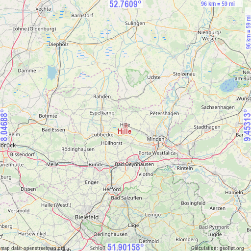
Hille GPS coordinates[2]
52° 19' 59.988" North, 8° 45' 0" East
| Map corner | latitude | longitude |
|---|---|---|
| Upper-left | 52.7609°, | 8.04688° |
| Center: | 52.33333°, | 8.75° |
| Lower-right: | 51.90158°, | 9.45313° |
| Map W x H: | 95.5×95.5 km | = 59.3×59.3mi |
| max Lat: | 55.01917° ⇑24.5% North |
| Hille: | 52.33333° |
| min Lat: | ⇓75.5% South 47.40724° |
| min Long | Hille | max Long |
| 5.92978° | 8.75° | 14.98853° |
| W 31.4%⇐ | ⇒68.6% E |
Elevation
Elevation of Hille is 58 m = 190 ft, and this is 191.1 m = 627 ft below average elevation for this country.
| Max E: |
1256 m = 4121 ft | 76.4% |
| Avg. | 249.1 m = 817 ft | |
| Hille | 58 m = 190 ft | |
Min E: |
-5 m = -16 ft | 23.6% |
See also: Germany elevation on elevation.city.
Geographical zone
Hille is located in North temperate zone (between Tropic of Cancer and the Arctic Circle). Distance of this North polar circle is 1582.3 km =983.2 mi to North.| Distance of | km | miles | from Hille |
|---|---|---|---|
| North Pole | 4188.1 | 2602.4 | to North |
| Arctic Circle | 1582.3 | 983.2 | to North |
| Tropic Cancer | 3213 | 1996.5 | to South |
| Equator | 5818.9 | 3615.7 | to South |


Nearby cities:
15 places around Hille: (largest is in red/bold)
• Bad Holzhausen
15.1 km =9.4 mi,  251°
251°
• Bad Oeynhausen
14.5 km =9 mi,  165°
165°
• Espelkamp
10.3 km =6.4 mi,  302°
302°
• Halle
15.3 km =9.5 mi,  49°
49°
• Hüllhorst
7.9 km =4.9 mi,  225°
225°
• Kirchlengern
16.8 km =10.4 mi,  208°
208°
• Löhne
16.6 km =10.3 mi,  193°
193°
• Lübbecke
9.7 km =6 mi, 252°
• Minden
12.2 km =7.6 mi,  113°
113°
• Obernbeck
15 km =9.3 mi, 192°
• Petershagen
15.3 km =9.5 mi,  72°
72°
• Porta Westfalica
16.1 km =10 mi,  135°
135°
• Preußisch Oldendorf
17.7 km =11 mi,  260°
260°
• Rahden
14.5 km =9 mi,  320°
320°
• Warmsen
15.3 km =9.5 mi,  26°
26°
Sources, notices
• [Note1] Compared only with cities in Germany existing in our database
• [Src1] Map data: © OpenStreetMap contributors (CC-BY-SA)
• [Src2] Other city data from geonames.org with taken over terms of usage.
• [Src3] Geographical zone / Annual Mean Temperature by Robert A. Rohde @ Wikipedia
