Berg geodata
Berg (Bavaria) is a populated place; located in Germany in Europe/Berlin (GMT+2) time zone. With population of 7,472 people, there are 2078 cities with bigger population in this country. Compared to other cities in Germany, 68.6% of cities are located further ↑North; 83.8% of cities are located further ←West and 87.9% of cities have lower elevation than Berg. Note1
Administrative division(s):
- Level 1: Bavaria
- Level 2: Upper Palatinate
- Level 3: Landkreis Neustadt an der Waldnaab
- Level 4: Windischeschenbach


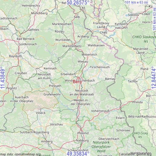
Berg GPS coordinates[2]
49° 48' 51.012" North, 12° 8' 29.796" East
| Map corner | latitude | longitude |
|---|---|---|
| Upper-left | 50.26575°, | 11.43849° |
| Center: | 49.81417°, | 12.14161° |
| Lower-right: | 49.35834°, | 12.84474° |
| Map W x H: | 100.9×100.9 km | = 62.7×62.7mi |
| max Lat: | 55.01917° ⇑68.6% North |
| Berg: | 49.81417° |
| min Lat: | ⇓31.4% South 47.40724° |
| min Long | Berg | max Long |
| 5.92978° | 12.14161° | 14.98853° |
| W 83.8%⇐ | ⇒16.2% E |
Elevation
Elevation of Berg is 493 m = 1617 ft, and this is 243.9 m = 800 ft above average elevation for this country.
| Max E: |
1256 m = 4121 ft | 12.1% |
| Berg | 493 m 1617 ft | |
| Avg. | 249.1 m = 817 ft | |
Min E: |
-5 m = -16 ft | 87.9% |
See also: Germany elevation on elevation.city.
Geographical zone
Berg is located in North temperate zone (between Tropic of Cancer and the Arctic Circle). Distance of this North polar circle is 1862.4 km =1157.2 mi to North.| Distance of | km | miles | from Berg |
|---|---|---|---|
| North Pole | 4468.2 | 2776.4 | to North |
| Arctic Circle | 1862.4 | 1157.2 | to North |
| Tropic Cancer | 2932.9 | 1822.4 | to South |
| Equator | 5538.8 | 3441.6 | to South |


Nearby cities:
15 places around Berg: (largest is in red/bold)
• Erbendorf
7.4 km =4.6 mi,  292°
292°
• Falkenberg
7.8 km =4.8 mi,  51°
51°
• Floß
13.9 km =8.6 mi,  136°
136°
• Friedenfels
8.1 km =5 mi,  339°
339°
• Fuchsmühl
12.1 km =7.5 mi,  1°
1°
• Kirchendemenreuth
4.5 km =2.8 mi,  221°
221°
• Konradsreuth
13.7 km =8.5 mi,  125°
125°
• Krummennaab
3.7 km =2.3 mi,  305°
305°
• Neustadt an der Waldnaab
9.4 km =5.8 mi,  163°
163°
• Parkstein
10.8 km =6.7 mi,  209°
209°
• Püchersreuth
9.7 km =6 mi, 137°
• Schwarzenbach
14.4 km =8.9 mi,  226°
226°
• Störnstein
10.2 km =6.3 mi,  153°
153°
• Wiesau
11 km =6.8 mi,  17°
17°
• Windischeschenbach
1.8 km =1.1 mi, 142°
Sources, notices
• [Note1] Compared only with cities in Germany existing in our database
• [Src1] Map data: © OpenStreetMap contributors (CC-BY-SA)
• [Src2] Other city data from geonames.org with taken over terms of usage.
• [Src3] Geographical zone / Annual Mean Temperature by Robert A. Rohde @ Wikipedia
