Neudenau geodata
Neudenau (Baden-Württemberg) is a populated place; located in Germany in Europe/Berlin (GMT+2) time zone. With population of 5,102 people, there are 2790 cities with bigger population in this country. Compared to other cities in Germany, 78.8% of cities are located further ↑North; 61.1% of cities are located further →East and 55.9% of cities have higher elevation than Neudenau. Note1
Administrative division(s):
- Level 1: Baden-Württemberg
- Level 2: Regierungsbezirk Stuttgart
- Level 3: Landkreis Heilbronn
- Level 4: Neudenau


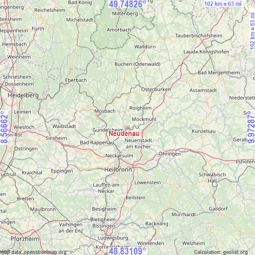
Neudenau GPS coordinates[2]
49° 17' 30.516" North, 9° 16' 11.1" East
| Map corner | latitude | longitude |
|---|---|---|
| Upper-left | 49.74826°, | 8.56662° |
| Center: | 49.29181°, | 9.26975° |
| Lower-right: | 48.83109°, | 9.97287° |
| Map W x H: | 102×102 km | = 63.4×63.4mi |
| max Lat: | 55.01917° ⇑78.8% North |
| Neudenau: | 49.29181° |
| min Lat: | ⇓21.2% South 47.40724° |
| min Long | Neudenau | max Long |
| 5.92978° | 9.26975° | 14.98853° |
| W 38.9%⇐ | ⇒61.1% E |
Elevation
Elevation of Neudenau is 182 m = 597 ft, and this is 67.1 m = 220 ft below average elevation for this country.
| Max E: |
1256 m = 4121 ft | 55.9% |
| Avg. | 249.1 m = 817 ft | |
| Neudenau | 182 m = 597 ft | |
Min E: |
-5 m = -16 ft | 44.1% |
See also: Germany elevation on elevation.city.
Geographical zone
Neudenau is located in North temperate zone (between Tropic of Cancer and the Arctic Circle). Distance of this North polar circle is 1920.4 km =1193.3 mi to North.| Distance of | km | miles | from Neudenau |
|---|---|---|---|
| North Pole | 4526.3 | 2812.5 | to North |
| Arctic Circle | 1920.4 | 1193.3 | to North |
| Tropic Cancer | 2874.8 | 1786.3 | to South |
| Equator | 5480.7 | 3405.5 | to South |


Nearby cities:
15 places around Neudenau: (largest is in red/bold)
• Bad Wimpfen
10.7 km =6.6 mi,  229°
229°
• Billigheim
6.4 km =4 mi,  349°
349°
• Eberstadt
12.9 km =8 mi,  163°
163°
• Gundelsheim
8 km =5 mi,  263°
263°
• Haßmersheim
8.7 km =5.4 mi,  275°
275°
• Mosbach
11 km =6.8 mi,  308°
308°
• Möckmühl
7.4 km =4.6 mi,  60°
60°
• Neckarsulm
11.9 km =7.4 mi,  195°
195°
• Neckarzimmern
10.4 km =6.5 mi,  287°
287°
• Neuenstadt am Kocher
7.8 km =4.8 mi,  144°
144°
• Oedheim
5.9 km =3.7 mi,  191°
191°
• Offenau
9.4 km =5.8 mi,  237°
237°
• Roigheim
9.6 km =6 mi,  32°
32°
• Untereisesheim
10.2 km =6.3 mi,  208°
208°
• Widdern
11.4 km =7.1 mi,  75°
75°
Sources, notices
• [Note1] Compared only with cities in Germany existing in our database
• [Src1] Map data: © OpenStreetMap contributors (CC-BY-SA)
• [Src2] Other city data from geonames.org with taken over terms of usage.
• [Src3] Geographical zone / Annual Mean Temperature by Robert A. Rohde @ Wikipedia
