Wölferbütt geodata
Wölferbütt (Thuringia) is a seat of a fourth-order administrative division; located in Germany in Europe/Berlin (GMT+2) time zone. With population of 436 people, there are 9582 cities with bigger population in this country. Compared to other cities in Germany, 53.5% of cities are located further ↓South; 50.8% of cities are located further ←West and 74.8% of cities have lower elevation than Wölferbütt. Note1


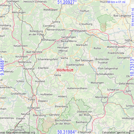
Wölferbütt GPS coordinates[2]
50° 46' 0.012" North, 10° 3' 0" East
| Map corner | latitude | longitude |
|---|---|---|
| Upper-left | 51.20927°, | 9.34688° |
| Center: | 50.76667°, | 10.05° |
| Lower-right: | 50.31984°, | 10.75313° |
| Map W x H: | 98.9×98.9 km | = 61.5×61.5mi |
| max Lat: | 55.01917° ⇑46.5% North |
| Wölferbütt: | 50.76667° |
| min Lat: | ⇓53.5% South 47.40724° |
| min Long | Wölferbütt | max Long |
| 5.92978° | 10.05° | 14.98853° |
| W 50.8%⇐ | ⇒49.2% E |
Elevation
Elevation of Wölferbütt is 396 m = 1299 ft, and this is 146.9 m = 482 ft above average elevation for this country.
| Max E: |
1256 m = 4121 ft | 25.2% |
| Wölferbütt | 396 m 1299 ft | |
| Avg. | 249.1 m = 817 ft | |
Min E: |
-5 m = -16 ft | 74.8% |
See also: Germany elevation on elevation.city.
Geographical zone
Wölferbütt is located in North temperate zone (between Tropic of Cancer and the Arctic Circle). Distance of this North polar circle is 1756.4 km =1091.4 mi to North.| Distance of | km | miles | from Wölferbütt |
|---|---|---|---|
| North Pole | 4362.3 | 2710.6 | to North |
| Arctic Circle | 1756.4 | 1091.4 | to North |
| Tropic Cancer | 3038.8 | 1888.2 | to South |
| Equator | 5644.7 | 3507.5 | to South |


Nearby cities:
15 places around Wölferbütt: (largest is in red/bold)
• Buttlar
6.9 km =4.3 mi,  261°
261°
• Dermbach
7.6 km =4.7 mi,  140°
140°
• Dorndorf
8.1 km =5 mi,  20°
20°
• Geisa
9.1 km =5.7 mi,  230°
230°
• Martinroda
3.9 km =2.4 mi, 17°
• Neidhartshausen
11 km =6.8 mi,  147°
147°
• Oechsen
2.5 km =1.6 mi,  159°
159°
• Philippsthal
8.6 km =5.3 mi,  340°
340°
• Schleid
9.5 km =5.9 mi,  218°
218°
• Stadtlengsfeld
5.9 km =3.7 mi,  71°
71°
• Unterbreizbach
7.3 km =4.5 mi,  319°
319°
• Urnshausen
9.4 km =5.8 mi,  112°
112°
• Vacha
7.1 km =4.4 mi, 343°
• Völkershausen
3.7 km =2.3 mi,  0°
0°
• Weilar
7 km =4.3 mi,  90°
90°
Sources, notices
• [Note1] Compared only with cities in Germany existing in our database
• [Src1] Map data: © OpenStreetMap contributors (CC-BY-SA)
• [Src2] Other city data from geonames.org with taken over terms of usage.
• [Src3] Geographical zone / Annual Mean Temperature by Robert A. Rohde @ Wikipedia
