Stadtlengsfeld geodata
Stadtlengsfeld (Thuringia) is a populated place; located in Germany in Europe/Berlin (GMT+2) time zone. With population of 2,698 people, there are 4233 cities with bigger population in this country. Compared to other cities in Germany, 53.8% of cities are located further ↓South; 52.1% of cities are located further ←West and 57.9% of cities have lower elevation than Stadtlengsfeld. Note1


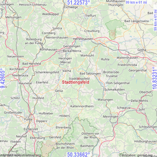
Stadtlengsfeld GPS coordinates[2]
50° 46' 59.844" North, 10° 7' 45.048" East
| Map corner | latitude | longitude |
|---|---|---|
| Upper-left | 51.22573°, | 9.42605° |
| Center: | 50.78329°, | 10.12918° |
| Lower-right: | 50.33662°, | 10.83231° |
| Map W x H: | 98.9×98.9 km | = 61.5×61.5mi |
| max Lat: | 55.01917° ⇑46.2% North |
| Stadtlengsfeld: | 50.78329° |
| min Lat: | ⇓53.8% South 47.40724° |
| min Long | Stadtlengsfeld | max Long |
| 5.92978° | 10.12918° | 14.98853° |
| W 52.1%⇐ | ⇒47.9% E |
Elevation
Elevation of Stadtlengsfeld is 278 m = 912 ft, and this is 28.9 m = 95 ft above average elevation for this country.
| Max E: |
1256 m = 4121 ft | 42.1% |
| Stadtlengsfeld | 278 m 912 ft | |
| Avg. | 249.1 m = 817 ft | |
Min E: |
-5 m = -16 ft | 57.9% |
See also: Germany elevation on elevation.city.
Geographical zone
Stadtlengsfeld is located in North temperate zone (between Tropic of Cancer and the Arctic Circle). Distance of this North polar circle is 1754.6 km =1090.3 mi to North.| Distance of | km | miles | from Stadtlengsfeld |
|---|---|---|---|
| North Pole | 4360.5 | 2709.5 | to North |
| Arctic Circle | 1754.6 | 1090.3 | to North |
| Tropic Cancer | 3040.7 | 1889.4 | to South |
| Equator | 5646.6 | 3508.6 | to South |


Nearby cities:
15 places around Stadtlengsfeld: (largest is in red/bold)
• Bad Salzungen
8.2 km =5.1 mi,  65°
65°
• Dermbach
7.8 km =4.8 mi,  185°
185°
• Dorndorf
6.4 km =4 mi,  333°
333°
• Immelborn
10.5 km =6.5 mi,  84°
84°
• Leimbach
6.2 km =3.9 mi,  53°
53°
• Martinroda
4.8 km =3 mi,  292°
292°
• Oechsen
6.3 km =3.9 mi,  227°
227°
• Philippsthal
10.5 km =6.5 mi,  306°
306°
• Tiefenort
6.8 km =4.2 mi,  22°
22°
• Urnshausen
6.2 km =3.9 mi,  149°
149°
• Vacha
9 km =5.6 mi,  303°
303°
• Völkershausen
5.9 km =3.7 mi, 288°
• Weilar
2.4 km =1.5 mi,  141°
141°
• Wiesenthal
9.6 km =6 mi,  164°
164°
• Wölferbütt
5.9 km =3.7 mi,  251°
251°
Sources, notices
• [Note1] Compared only with cities in Germany existing in our database
• [Src1] Map data: © OpenStreetMap contributors (CC-BY-SA)
• [Src2] Other city data from geonames.org with taken over terms of usage.
• [Src3] Geographical zone / Annual Mean Temperature by Robert A. Rohde @ Wikipedia
