Völkershausen geodata
Völkershausen (Thuringia) is a seat of a fourth-order administrative division; located in Germany in Europe/Berlin (GMT+2) time zone. With population of 1,206 people, there are 6547 cities with bigger population in this country. Compared to other cities in Germany, 54.1% of cities are located further ↓South; 50.8% of cities are located further ←West and 62.3% of cities have lower elevation than Völkershausen. Note1


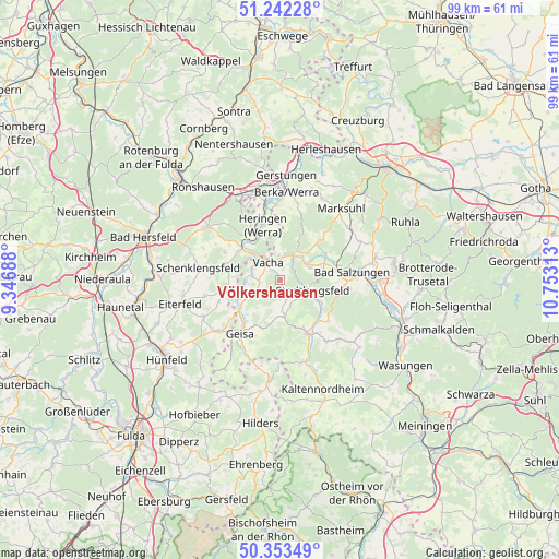
Völkershausen GPS coordinates[2]
50° 48' 0" North, 10° 3' 0" East
| Map corner | latitude | longitude |
|---|---|---|
| Upper-left | 51.24228°, | 9.34688° |
| Center: | 50.8°, | 10.05° |
| Lower-right: | 50.35349°, | 10.75313° |
| Map W x H: | 98.8×98.8 km | = 61.4×61.4mi |
| max Lat: | 55.01917° ⇑45.9% North |
| Völkershausen: | 50.8° |
| min Lat: | ⇓54.1% South 47.40724° |
| min Long | Völkershausen | max Long |
| 5.92978° | 10.05° | 14.98853° |
| W 50.8%⇐ | ⇒49.2% E |
Elevation
Elevation of Völkershausen is 304 m = 997 ft, and this is 54.9 m = 180 ft above average elevation for this country.
| Max E: |
1256 m = 4121 ft | 37.7% |
| Völkershausen | 304 m 997 ft | |
| Avg. | 249.1 m = 817 ft | |
Min E: |
-5 m = -16 ft | 62.3% |
See also: Germany elevation on elevation.city.
Geographical zone
Völkershausen is located in North temperate zone (between Tropic of Cancer and the Arctic Circle). Distance of this North polar circle is 1752.7 km =1089.1 mi to North.| Distance of | km | miles | from Völkershausen |
|---|---|---|---|
| North Pole | 4358.6 | 2708.3 | to North |
| Arctic Circle | 1752.7 | 1089.1 | to North |
| Tropic Cancer | 3042.5 | 1890.5 | to South |
| Equator | 5648.4 | 3509.8 | to South |


Nearby cities:
15 places around Völkershausen: (largest is in red/bold)
• Buttlar
8.3 km =5.2 mi,  235°
235°
• Dermbach
10.7 km =6.6 mi,  153°
153°
• Dorndorf
4.7 km =2.9 mi,  35°
35°
• Frauensee
10.8 km =6.7 mi, 36°
• Heringen
10.2 km =6.3 mi,  342°
342°
• Leimbach
10.7 km =6.6 mi,  80°
80°
• Martinroda
1.2 km =0.7 mi,  90°
90°
• Oechsen
6.1 km =3.8 mi,  171°
171°
• Philippsthal
5.2 km =3.2 mi,  326°
326°
• Stadtlengsfeld
5.9 km =3.7 mi,  108°
108°
• Tiefenort
9.3 km =5.8 mi,  61°
61°
• Unterbreizbach
5 km =3.1 mi,  291°
291°
• Vacha
3.7 km =2.3 mi, 327°
• Weilar
7.9 km =4.9 mi,  117°
117°
• Wölferbütt
3.7 km =2.3 mi,  180°
180°
Sources, notices
• [Note1] Compared only with cities in Germany existing in our database
• [Src1] Map data: © OpenStreetMap contributors (CC-BY-SA)
• [Src2] Other city data from geonames.org with taken over terms of usage.
• [Src3] Geographical zone / Annual Mean Temperature by Robert A. Rohde @ Wikipedia
