Vacha geodata
Vacha (Thuringia) is a populated place; located in Germany in Europe/Berlin (GMT+2) time zone. With population of 3,856 people, there are 3379 cities with bigger population in this country. Compared to other cities in Germany, 54.8% of cities are located further ↓South; 50.5% of cities are located further ←West and 51.6% of cities have lower elevation than Vacha. Note1


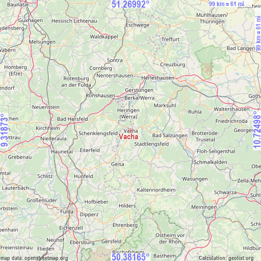
Vacha GPS coordinates[2]
50° 49' 40.44" North, 10° 1' 18.66" East
| Map corner | latitude | longitude |
|---|---|---|
| Upper-left | 51.26992°, | 9.31873° |
| Center: | 50.8279°, | 10.02185° |
| Lower-right: | 50.38165°, | 10.72498° |
| Map W x H: | 98.8×98.8 km | = 61.4×61.4mi |
| max Lat: | 55.01917° ⇑45.2% North |
| Vacha: | 50.8279° |
| min Lat: | ⇓54.8% South 47.40724° |
| min Long | Vacha | max Long |
| 5.92978° | 10.02185° | 14.98853° |
| W 50.5%⇐ | ⇒49.5% E |
Elevation
Elevation of Vacha is 237 m = 778 ft, and this is 12.1 m = 40 ft below average elevation for this country.
| Max E: |
1256 m = 4121 ft | 48.4% |
| Avg. | 249.1 m = 817 ft | |
| Vacha | 237 m = 778 ft | |
Min E: |
-5 m = -16 ft | 51.6% |
See also: Germany elevation on elevation.city.
Geographical zone
Vacha is located in North temperate zone (between Tropic of Cancer and the Arctic Circle). Distance of this North polar circle is 1749.6 km =1087.2 mi to North.| Distance of | km | miles | from Vacha |
|---|---|---|---|
| North Pole | 4355.5 | 2706.4 | to North |
| Arctic Circle | 1749.6 | 1087.2 | to North |
| Tropic Cancer | 3045.6 | 1892.4 | to South |
| Equator | 5651.5 | 3511.7 | to South |


Nearby cities:
15 places around Vacha: (largest is in red/bold)
• Buttlar
9.2 km =5.7 mi,  211°
211°
• Dankmarshausen
10.8 km =6.7 mi,  357°
357°
• Dippach
10.3 km =6.4 mi,  8°
8°
• Dorndorf
4.8 km =3 mi,  80°
80°
• Frauensee
10.1 km =6.3 mi,  56°
56°
• Heringen
6.8 km =4.2 mi,  351°
351°
• Martinroda
4.4 km =2.7 mi,  134°
134°
• Oechsen
9.6 km =6 mi,  162°
162°
• Philippsthal
1.6 km =1 mi,  325°
325°
• Stadtlengsfeld
9 km =5.6 mi,  123°
123°
• Tiefenort
10.2 km =6.3 mi, 82°
• Unterbreizbach
3 km =1.9 mi,  245°
245°
• Völkershausen
3.7 km =2.3 mi,  147°
147°
• Weilar
11.3 km =7 mi, 127°
• Wölferbütt
7.1 km =4.4 mi, 163°
Sources, notices
• [Note1] Compared only with cities in Germany existing in our database
• [Src1] Map data: © OpenStreetMap contributors (CC-BY-SA)
• [Src2] Other city data from geonames.org with taken over terms of usage.
• [Src3] Geographical zone / Annual Mean Temperature by Robert A. Rohde @ Wikipedia
