Rheinbreitbach geodata
Rheinbreitbach (Rheinland-Pfalz) is a seat of a fourth-order administrative division; located in Germany in Europe/Berlin (GMT+2) time zone. With population of 4,598 people, there are 2986 cities with bigger population in this country. Compared to other cities in Germany, 50.2% of cities are located further ↑North; 91% of cities are located further →East and 69.5% of cities have higher elevation than Rheinbreitbach. Note1
Administrative division(s):
- Level 1: Rheinland-Pfalz
- Level 3: Landkreis Neuwied
- Level 4: Rheinbreitbach


Rheinbreitbach GPS coordinates[2]
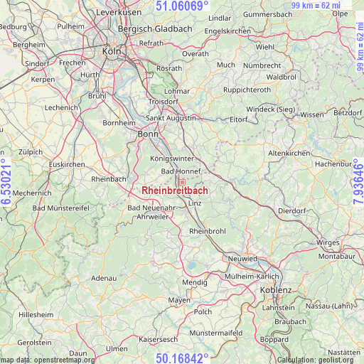
50° 37' 0.012" North, 7° 13' 59.988" East
| Map corner | latitude | longitude |
|---|---|---|
| Upper-left | 51.06069°, | 6.53021° |
| Center: | 50.61667°, | 7.23333° |
| Lower-right: | 50.16842°, | 7.93646° |
| Map W x H: | 99.2×99.2 km | = 61.6×61.6mi |
| max Lat: | 55.01917° ⇑50.2% North |
| Rheinbreitbach: | 50.61667° |
| min Lat: | ⇓49.8% South 47.40724° |
| min Long | Rheinbreitbach | max Long |
| 5.92978° | 7.23333° | 14.98853° |
| W 9%⇐ | ⇒91% E |
Elevation
Elevation of Rheinbreitbach is 94 m = 308 ft, and this is 155.1 m = 509 ft below average elevation for this country.
| Max E: |
1256 m = 4121 ft | 69.5% |
| Avg. | 249.1 m = 817 ft | |
| Rheinbreitbach | 94 m = 308 ft | |
Min E: |
-5 m = -16 ft | 30.5% |
See also: Germany elevation on elevation.city.
Geographical zone
Rheinbreitbach is located in North temperate zone (between Tropic of Cancer and the Arctic Circle). Distance of this North polar circle is 1773.1 km =1101.8 mi to North.| Distance of | km | miles | from Rheinbreitbach |
|---|---|---|---|
| North Pole | 4379 | 2721 | to North |
| Arctic Circle | 1773.1 | 1101.8 | to North |
| Tropic Cancer | 3022.1 | 1877.8 | to South |
| Equator | 5628 | 3497.1 | to South |


Nearby cities:
15 places around Rheinbreitbach: (largest is in red/bold)
• Bad Honnef
3 km =1.9 mi,  352°
352°
• Bruchhausen
2.2 km =1.4 mi,  147°
147°
• Dattenberg
8.2 km =5.1 mi, 148°
• Erpel
3.7 km =2.3 mi,  180°
180°
• Kalenborn
5.8 km =3.6 mi,  91°
91°
• Kasbach-Ohlenberg
4.4 km =2.7 mi, 147°
• Königswinter
8.2 km =5.1 mi,  336°
336°
• Leubsdorf
8.8 km =5.5 mi, 147°
• Linz am Rhein
6.4 km =4 mi, 145°
• Ockenfels
5.4 km =3.4 mi, 146°
• Remagen
4.2 km =2.6 mi,  186°
186°
• Sinzig
8.2 km =5.1 mi,  173°
173°
• Unkel
2.5 km =1.6 mi,  204°
204°
• Vettelschoß
8.2 km =5.1 mi, 90°
• Windhagen
8.9 km =5.5 mi,  72°
72°
Sources, notices
• [Note1] Compared only with cities in Germany existing in our database
• [Src1] Map data: © OpenStreetMap contributors (CC-BY-SA)
• [Src2] Other city data from geonames.org with taken over terms of usage.
• [Src3] Geographical zone / Annual Mean Temperature by Robert A. Rohde @ Wikipedia
