Oberthal geodata
Oberthal (Saarland) is a seat of a fourth-order administrative division; located in Germany in Europe/Berlin (GMT+2) time zone. With population of 6,581 people, there are 2283 cities with bigger population in this country. Compared to other cities in Germany, 75.5% of cities are located further ↑North; 92.5% of cities are located further →East and 64.5% of cities have lower elevation than Oberthal. Note1


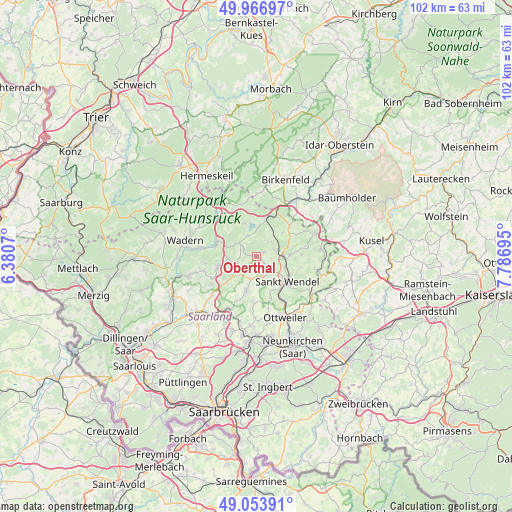
Oberthal GPS coordinates[2]
49° 30' 45.252" North, 7° 5' 1.752" East
| Map corner | latitude | longitude |
|---|---|---|
| Upper-left | 49.96697°, | 6.3807° |
| Center: | 49.51257°, | 7.08382° |
| Lower-right: | 49.05391°, | 7.78695° |
| Map W x H: | 101.5×101.5 km | = 63.1×63.1mi |
| max Lat: | 55.01917° ⇑75.5% North |
| Oberthal: | 49.51257° |
| min Lat: | ⇓24.5% South 47.40724° |
| min Long | Oberthal | max Long |
| 5.92978° | 7.08382° | 14.98853° |
| W 7.5%⇐ | ⇒92.5% E |
Elevation
Elevation of Oberthal is 318 m = 1043 ft, and this is 68.9 m = 226 ft above average elevation for this country.
| Max E: |
1256 m = 4121 ft | 35.5% |
| Oberthal | 318 m 1043 ft | |
| Avg. | 249.1 m = 817 ft | |
Min E: |
-5 m = -16 ft | 64.5% |
See also: Germany elevation on elevation.city.
Geographical zone
Oberthal is located in North temperate zone (between Tropic of Cancer and the Arctic Circle). Distance of this North polar circle is 1895.9 km =1178.1 mi to North.| Distance of | km | miles | from Oberthal |
|---|---|---|---|
| North Pole | 4501.8 | 2797.3 | to North |
| Arctic Circle | 1895.9 | 1178.1 | to North |
| Tropic Cancer | 2899.4 | 1801.6 | to South |
| Equator | 5505.3 | 3420.8 | to South |


Nearby cities:
15 places around Oberthal: (largest is in red/bold)
• Achtelsbach
12.5 km =7.8 mi,  2°
2°
• Ellweiler
12.5 km =7.8 mi,  22°
22°
• Freisen
12.7 km =7.9 mi,  70°
70°
• Gimbweiler
11.5 km =7.1 mi,  46°
46°
• Hahnweiler
11.3 km =7 mi,  57°
57°
• Leitzweiler
12.4 km =7.7 mi, 50°
• Mainzweiler
10.9 km =6.8 mi,  166°
166°
• Marpingen
7 km =4.3 mi,  195°
195°
• Meckenbach
11.6 km =7.2 mi,  5°
5°
• Namborn
4.2 km =2.6 mi,  76°
76°
• Nohfelden
9.3 km =5.8 mi,  27°
27°
• Nonnweiler
13.4 km =8.3 mi,  322°
322°
• Rückweiler
13.4 km =8.3 mi, 53°
• Sankt Wendel
8 km =5 mi,  130°
130°
• Tholey
4.7 km =2.9 mi,  226°
226°
Sources, notices
• [Note1] Compared only with cities in Germany existing in our database
• [Src1] Map data: © OpenStreetMap contributors (CC-BY-SA)
• [Src2] Other city data from geonames.org with taken over terms of usage.
• [Src3] Geographical zone / Annual Mean Temperature by Robert A. Rohde @ Wikipedia
