Sankt Wendel geodata
Sankt Wendel (Saarland) is a seat of a third-order administrative division; located in Germany in Europe/Berlin (GMT+2) time zone. With population of 26,904 people, there are 540 cities with bigger population in this country. Compared to other cities in Germany, 76.3% of cities are located further ↑North; 91.7% of cities are located further →East and 58.3% of cities have lower elevation than Sankt Wendel. Note1
Administrative division(s):
- Level 1: Saarland
- Level 3: Landkreis Sankt Wendel
- Level 4: St. Wendel, Kreisstadt


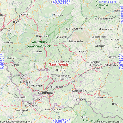
Sankt Wendel GPS coordinates[2]
49° 27' 58.788" North, 7° 10' 5.304" East
| Map corner | latitude | longitude |
|---|---|---|
| Upper-left | 49.92116°, | 6.46501° |
| Center: | 49.46633°, | 7.16814° |
| Lower-right: | 49.00724°, | 7.87126° |
| Map W x H: | 101.6×101.6 km | = 63.1×63.1mi |
| max Lat: | 55.01917° ⇑76.3% North |
| Sankt Wendel: | 49.46633° |
| min Lat: | ⇓23.7% South 47.40724° |
| min Long | Sankt Wendel | max Long |
| 5.92978° | 7.16814° | 14.98853° |
| W 8.3%⇐ | ⇒91.7% E |
Elevation
Elevation of Sankt Wendel is 280 m = 919 ft, and this is 30.9 m = 101 ft above average elevation for this country.
| Max E: |
1256 m = 4121 ft | 41.7% |
| Sankt Wendel | 280 m 919 ft | |
| Avg. | 249.1 m = 817 ft | |
Min E: |
-5 m = -16 ft | 58.3% |
See also: Germany elevation on elevation.city.
Geographical zone
Sankt Wendel is located in North temperate zone (between Tropic of Cancer and the Arctic Circle). Distance of this North polar circle is 1901 km =1181.2 mi to North.| Distance of | km | miles | from Sankt Wendel |
|---|---|---|---|
| North Pole | 4506.9 | 2800.5 | to North |
| Arctic Circle | 1901 | 1181.2 | to North |
| Tropic Cancer | 2894.2 | 1798.4 | to South |
| Equator | 5500.1 | 3417.6 | to South |


Nearby cities:
15 places around Sankt Wendel: (largest is in red/bold)
• Altenkirchen
11.3 km =7 mi,  103°
103°
• Breitenbach
8 km =5 mi,  117°
117°
• Dunzweiler
11.4 km =7.1 mi, 119°
• Freisen
11 km =6.8 mi,  32°
32°
• Frohnhofen
9.6 km =6 mi, 98°
• Hangard
9.8 km =6.1 mi,  161°
161°
• Herchweiler
10.5 km =6.5 mi,  59°
59°
• Mainzweiler
6.6 km =4.1 mi,  213°
213°
• Marpingen
8.1 km =5 mi,  258°
258°
• Namborn
6.5 km =4 mi,  342°
342°
• Oberthal
8 km =5 mi,  310°
310°
• Ottweiler
7.2 km =4.5 mi,  182°
182°
• Reichweiler
11.2 km =7 mi,  48°
48°
• Selchenbach
10.2 km =6.3 mi,  68°
68°
• Tholey
9.7 km =6 mi,  281°
281°
Sources, notices
• [Note1] Compared only with cities in Germany existing in our database
• [Src1] Map data: © OpenStreetMap contributors (CC-BY-SA)
• [Src2] Other city data from geonames.org with taken over terms of usage.
• [Src3] Geographical zone / Annual Mean Temperature by Robert A. Rohde @ Wikipedia
